| Mount Kialagvik | |
|---|---|
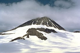
 A photo of Mount Kialagvik, taken by T.P. Miller of the United States Geological Survey in July 1979. A photo of Mount Kialagvik, taken by T.P. Miller of the United States Geological Survey in July 1979. | |
| Highest point | |
| Elevation | 5,167 ft (1,575 m) |
| Prominence | 3,445 ft (1,050 m) |
| Listing | List of volcanoes in the United States of America |
| Coordinates | 57°12′11″N 156°44′42″W / 57.203°N 156.745°W / 57.203; -156.745 |
| Geography | |
 | |
| Location | Alaska Peninsula, Alaska, USA |
| Parent range | Aleutian Range |
| Topo map | USGS Ugashik A-3 |
| Geology | |
| Rock age | Holocene |
| Mountain type | Stratovolcano |
| Volcanic arc | Aleutian Arc |
| Last eruption | Unknown |
Mount Kialagvik is a small, poorly known stratovolcano on the Alaska Peninsula of Alaska, United States, located in the Aleutian Range about 10 miles (16 km) northeast of Mount Chiginagak. It is informally named after the Eskimo word for nearby Wide Bay. Kialagvik has not erupted in historic time.
See also
References
- Alaska Volcano Observatory, AVO Image 13925: Kialagvik, Retrieved Jan. 6, 2023.
- ^ Alaska Volcano Observatory, Volcano Information -- Kialagvik, Retrieved Jan. 6, 2023.
- Peakbagger.com, Mount Kialagvik, Alaska, Retrieved Jan. 6, 2023.
- "Kialagvik". Global Volcanism Program. Smithsonian Institution. Retrieved 2021-06-28.
This article about a location in the Kodiak Island Borough, Alaska is a stub. You can help Misplaced Pages by expanding it. |