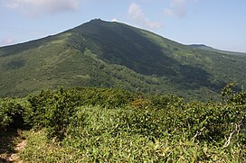
| Mount Mekunnai | |
|---|---|
| 目国内岳 | |
 Mount Mekunnai (Mekunnaidake) Mount Mekunnai (Mekunnaidake) | |
| Highest point | |
| Elevation | 1,220 m (4,000 ft) |
| Prominence | 673 m (2,208 ft) |
| Parent peak | Niseko Annupuri |
| Listing | List of mountains and hills of Japan by height |
| Coordinates | 42°54′13″N 140°28′10″E / 42.90361°N 140.46944°E / 42.90361; 140.46944 |
| Geography | |
| Location | Hokkaidō, Japan |
| Parent range | Mount Raiden Volcanic Group |
| Topo map(s) | Geographical Survey Institute 25000:1 チセヌプリ 50000:1 岩内 |
| Geology | |
| Rock age | Quaternary |
| Mountain type | pyroclastic cone |
| Volcanic arc | Northeastern Japan Arc |
Mount Mekunnai (目国内岳, Mekunnai-dake) is an andesitic volcano in the Mount Raiden Volcanic Group on the border between Iwanai and Rankoshi, Hokkaidō, Japan. Mount Mekunnai is a pyroclastic cone. The mountain consists of primarily non-alkali, mafic, volcanic rock. The rock is younger than that of neighboring Mount Raiden, being categorized at 700,000 to 13,000 years old. The rock is older than that of the Niseko Volcanic Group.
References
- "RAIDEN-YAMA". Quaternary Volcanoes of Japan. Geological Survey of Japan, AIST. 2006. Archived from the original on December 21, 2012. Retrieved 2008-10-01.
- "Niseko". Global Volcanism Program. Smithsonian National Museum of Natural History. Retrieved 2008-10-01.
- "Hokkaido". Seamless Digital Geological Map of Japan. Geological Survey of Japan, AIST. 2007. Retrieved 2010-10-12.
This Hokkaidō location article is a stub. You can help Misplaced Pages by expanding it. |