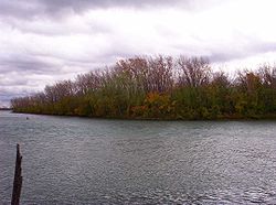
 USGS aerial imagery of Mud Island USGS aerial imagery of Mud Island | |
   | |
| Geography | |
|---|---|
| Location | Michigan |
| Coordinates | 42°14′20″N 83°08′27″W / 42.23889°N 83.14083°W / 42.23889; -83.14083 (Mud Island) |
| Highest elevation | 584 ft (178 m) |
| Administration | |
| United States | |
| State | |
| County | Wayne |

Mud Island is an island in the Detroit River International Wildlife Refuge, in southeast Michigan. It is in Wayne County. Its coordinates are 42°14′20″N 83°08′27″W / 42.23889°N 83.14083°W / 42.23889; -83.14083 (Mud Island); the United States Geological Survey gave its elevation as 584 ft (178 m) in 1980. Once owned by National Steel, white bass and perch are now caught there.
References
- ^ U.S. Geological Survey Geographic Names Information System: Mud Island
- "Wildlife refuge needs volunteers". Detroit Free Press. Detroit, Michigan. 2012-01-31. p. B5.
- ^ "A river runs through it". Detroit Free Press. Detroit, Michigan. 2003-05-08. p. 72.
- "Boyre Stops In Mud Island". Detroit Free Press. Detroit, Michigan. 1912-10-03. p. 13.
- "New navigation aids are placed in river". Detroit Free Press. Detroit, Michigan. 1917-10-11. p. 10.
- "More Navigation Aids Are Taken From Detroit River". Detroit Free Press. Detroit, Michigan. 1918-12-06. p. 11.
- "The Detroit River". Detroit River Coalition. Retrieved 2021-05-20.
- "Second underwater liquor cable found". Battle Creek Enquirer. Battle Creek, Michigan. 1929-09-28. p. 1.
- "Best state for catches: The Mitten". Detroit Free Press. Detroit, Michigan. 2017-05-28. p. C10.
This Wayne County, Michigan location article is a stub. You can help Misplaced Pages by expanding it. |