| Canelones | |
|---|---|
| Municipality | |
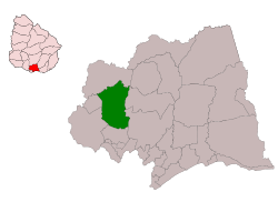
 Location of the municipality of Canelones within the department and Uruguay. Location of the municipality of Canelones within the department and Uruguay. | |
| Coordinates: 34°31′00″S 56°17′00″W / 34.51667°S 56.28333°W / -34.51667; -56.28333 | |
| Country | |
| Department | Canelones |
| Seat | Canelones |
| Government | |
| • Mayor | Mabel Curbelo |
| Area | |
| • Total | 226 km (87 sq mi) |
| Population | |
| • Total | 27,338 |
| • Density | 120/km (310/sq mi) |
| Demonym | canario/a |
Canelones is a Uruguayan municipality located in the department of Canelones. Its seat is the city of Canelones.
Location
The municipality is located in the central-western region of the department of Canelones, south of the creek Canelón Grande.
Populated places in the municipality of Canelones
- Canelones (department capital and municipality seat)
- Juanicó
- Barrio Remanso
- Parada Cabrera
- Villa Arejo
- Paso Palomeque
- Paso Espinosa
References
- Intendencia de Canelones. "Municipios de Canelones, Base de Datos" (in Spanish). Archived from the original (zip) on 2 February 2014. Retrieved 28 January 2014.
This article about a place in Canelones Department is a stub. You can help Misplaced Pages by expanding it. |