| Myloi Μύλοι | |
|---|---|
| Community | |
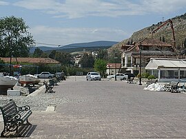
 A view of Myloi from the quay A view of Myloi from the quay | |
 | |
| Coordinates: 37°33′N 22°43′E / 37.550°N 22.717°E / 37.550; 22.717 | |
| Country | Greece |
| Administrative region | Peloponnese |
| Regional unit | Argolis |
| Municipality | Argos-Mykines |
| Municipal unit | Lerna |
| Elevation | 29 m (95 ft) |
| Population | |
| • Community | 940 |
| Time zone | UTC+2 (EET) |
| • Summer (DST) | UTC+3 (EEST) |
| Postal code | 212 00 |
| Area code(s) | 27510 |
| Vehicle registration | AP |
Myloi (Greek: Μύλοι), is a village in the southwestern part of Argolis, Greece. Myloi was the seat of the former municipality of Lerna. It is 4 km southwest of Nea Kios, 9 km south of Argos and 8 km west of Nafplio. The Greek National Road 7 passes through the village. It had a train station on the Corinth–Kalamata railway, but passenger service on this line was halted in 2010.
Situated on the northwestern coast of the Argolic Gulf, Myloi is a popular fishing village and local tourist destination for its beaches and restaurants, hotels, market, and bakery open for most of the year.
Sites
Lerna
Lerna is a Bronze Age settlement site located in Myloi that was occupied from the Neolithic to the Mycenean period (6th - 1st century BC). Excavated by the American School of Classical Studies in Athens, several buildings were recovered with the most famous being the House of the Tiles, a large monumental building names after the remains of baked roofing tiles.
The site is managed by the Ephorate of Antiquities of Argolida and can be visited with the price of admission.

Castle Kiveri
Built during the 14th century AD, the remains of the Castle of Kiveri. are located on Pontinos Hill, overlooking the Argolic Gulf. While there are mentions of a Temple of Athena Saitis by Pausanias in this location, the structures that remain date to the Frankish period and are attributed to Gautier de Brienne. The castle and surrounding structures are said to have been destroyed during the first Ottoman–Venetian War (1463–1479).
Today, a few standing structures remaining and a modern church can be found on the top of the hill.
Population
| Year | Population |
|---|---|
| 1981 | 698 |
| 1991 | 552 |
| 2001 | 921 |
| 2011 | 741 |
| 2021 | 940 |
See also
References
- "Αποτελέσματα Απογραφής Πληθυσμού - Κατοικιών 2021, Μόνιμος Πληθυσμός κατά οικισμό" [Results of the 2021 Population - Housing Census, Permanent population by settlement] (in Greek). Hellenic Statistical Authority. 29 March 2024.
- "Archaeological Site of Lerna, 'House of Tiles' & Stone Enclosure - Ephorate of Antiquities of Argolida". www.argolisculture.gr. Retrieved 2021-10-11.
- Papathanassiou, Manolis. "Castle of Lerna". Καστρολόγος. Retrieved 2021-10-11.
- "Castle Kiveri, Myloi - Ephorate of Antiquities of Argolida". www.argolisculture.gr. Retrieved 2021-10-11.
| Subdivisions of the municipality of Argos-Mykines | |
|---|---|
| Municipal unit of Achladokampos | |
| Municipal unit of Alea | |
| Municipal unit of Argos | |
| Municipal unit of Koutsopodi |
|
| Municipal unit of Lerna | |
| Municipal unit of Lyrkeia | |
| Municipal unit of Mykines |
|
| Municipal unit of Nea Kios | |