This article has multiple issues. Please help improve it or discuss these issues on the talk page. (Learn how and when to remove these messages)
|
 Santiago–Tuguegarao Road
 | ||||
|---|---|---|---|---|
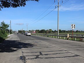
 The Ramon, Isabela segment of the road, with Route 51 sign The Ramon, Isabela segment of the road, with Route 51 sign | ||||
| Route information | ||||
| Length | 130 km (81 mi) | |||
| Component highways | ||||
| Major junctions | ||||
| South end | ||||
| Major intersections |
| |||
| North end | ||||
| Location | ||||
| Country | Philippines | |||
| Provinces | Cagayan, Kalinga, Isabela | |||
| Major cities | Tuguegarao, Tabuk, Santiago | |||
| Towns | Ramon, San Mateo, Cabatuan, Aurora, San Manuel, Roxas, Mallig, Quezon, Rizal, Santo Tomas, Santa Maria, Enrile, Solana | |||
| Highway system | ||||
| ||||
| ||||
Santiago–Tuguegarao Road is a major national primary road in the provinces of Cagayan, Kalinga, and Isabela in the Philippines. It is a bypass road of the Pan-Philippine Highway, also known as Cagayan Valley Road, connecting to the cities of Tuguegarao and Santiago.
The road is designated as National Route 51 (N51) of the Philippine highway network.
History
| This section is empty. You can help by adding to it. (September 2020) |
Route description

Santiago to Cabatuan
Santiago–Tuguegarao Road starts at Mabini Junction, a roundabout intersection with Maharlika Highway and R.C. Miranda Road in Barangay Mabini, Santiago City. Heading north, it then runs straight to the north where it traverses the municipalities of Ramon, San Mateo, and Cabatuan in Isabela.
Cabatuan to Santa Maria
At the poblacion of Cabatuan, the road turns north at its intersection with Santiago–Tuguegarao Bypass Road, where the Triangle Park is situated. It then crosses the Magat River vis Magat Bridge and traverses the municipalities of Aurora, San Manuel, Roxas, Mallig, and Quezon in Isabela before entering the province of Kalinga. In Kalinga, it traverses the lowland municipalities of Tabuk, the province's capital, and Rizal, away from their poblacions. It then re-enters Isabela and traverses the municipalities of Santo Tomas and Santa Maria.
Santa Maria to Tuguegarao

In Santa Maria, Isabela, the road makes a sharp left turn at its intersection with Cabagan–Santa Maria Road. It then enters the province of Cagayan and traverses the municipalities of Enrile and Solana, where it turns east at its intersection with Cagayan–Apayao Road. It crosses the Cagayan River through the Buntun Bridge and enters the city of Tuguegarao. Approaching the poblacion, it assumes local street names such as Luna Extension and Luna Street, respectively. At its intersection with Rizal Street, west of the Tuguegarao Cathedral, it turns north and assumes such local street name. It then turns northeast towards the Balzain Bridge II and becomes Balzain Highway. The road ends at the Tuguegarao Junction, a roundabout intersection with Maharlika Highway (Cagayan Valley Road) and Tuguegarao Diversion Road II.
Intersections
Intersections are numbered by kilometer post, with Rizal Park in Manila designated as kilometer zero.
| Region | Province | City/Municipality | km | mi | Destinations | Notes | |
|---|---|---|---|---|---|---|---|
| Cagayan Valley | Isabela | Santiago | 327 | 203 | Southern terminus. Roundabout intersection. | ||
| Ramon | 340.5 | 211.6 | Burgos–Aguinaldo Road | ||||
| 341.8 | 212.4 | ||||||
| San Mateo | 350.9 | 218.0 | Alicia–San Mateo Road | ||||
| Cabatuan | 361.9 | 224.9 | South end of bypass. | ||||
| 363.3 | 225.7 | North end of bypass. | |||||
| Roxas | 382.6 | 237.7 | Gamu–Roxas Road | ||||
| Mallig | 392.7 | 244.0 | Ilagan–Delfin Albano–Mallig Road | ||||
| Santa Maria | 432 | 268 | |||||
| Cordillera Administrative Region | Kalinga | Tabuk | 408.7 | 254.0 | Abbut–Agbannawag Road | ||
| Rizal | 419.6 | 260.7 | Rizal National Road | ||||
| Cagayan Valley | Isabela | Santa Maria | Cabagan–Santa Maria Road | ||||
| Cagayan | Enrile | 437 | 272 | ||||
| Solana | 452 | 281 | Cagayan–Apayao Road | ||||
| Tuguegarao | |||||||
| Locally known as College Avenue; south end of bypass | |||||||
| Rizal Street | Road assumes the name Rizal Street. | ||||||
| Locally known as College Avenue; north end of bypass. Road assumes the name Balzain Highway. | |||||||
| 456 | 283 | Northern terminus. Roundabout intersection. | |||||
| 1.000 mi = 1.609 km; 1.000 km = 0.621 mi | |||||||
Santiago–Tuguegarao Bypass Road
| Location | Cabatuan, Isabela |
|---|---|
| Length | 2.275 km (1.414 mi) |
The Santiago–Tuguegarao Bypass Road is short bypass of Santiago–Tuguegarao Road in Cabatuan, Isabela. This bypass road is designated as National Route 53 (N53) of the Philippine highway network. It connects Cabatuan, Luna and Cauayan.
References
- "Cagayan 3rd". www.dpwh.gov.ph. Retrieved February 13, 2019.
- "Isabela 1st". www.dpwh.gov.ph. Retrieved February 13, 2019.
- "Isabela 2nd". www.dpwh.gov.ph. Retrieved February 13, 2019.