| This article has been translated from the article Мост через Надым in the Russian Misplaced Pages, and requires proofreading. If you are confident enough in your fluency of English and Russian, please proofread it. (August 2022) |
| Nadym River Bridge Мост через Надым | |
|---|---|
 | |
| Coordinates | 65°33′11″N 72°43′13″E / 65.55306°N 72.72028°E / 65.55306; 72.72028 |
| Carries | combined (Trains, Motor vehicles) |
| Crosses | Nadym |
| Locale | Nadym, Yamalo-Nenets Autonomous Okrug, Tyumen Oblast |
| Characteristics | |
| Total length | 1334 m |
| Longest span | 110 m |
| History | |
| Opened | 2015 |
| Location | |
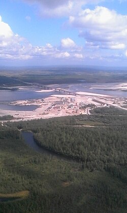
The Nadym River Bridge is a combined single-level bridge that was opened on September 11, 2015. It is located simultaneously on the Surgut – Salekhard highway and on the Salekhard – Nadym – Korotchaevo railway line. It is an element of the Northern Latitudinal Railway project, designed to link the Arctic region with the central areas of Russia and the Urals.
The total length of the passage is 3.1 km, including the bridge (1334 m) and access areas (1770 m). The length of the superstructure is 110 m. The construction started in 2011, and the road crossing was opened in 2015. The construction of the railway part of the bridge was postponed.
The construction companies that participated in the erection of the bridge are OJSC Mostostroy-11 , CJSC Kurganstalmost , and Llc Urengoydorstroy.
Notes
- "Строительство железнодорожной части моста через Надым «отложено в пользу шведов»".
- "Кобылкин в компании трех губернаторов и полпреда открыл мост через Надым. Не обошлось без новых российских трендов".