| This article needs additional citations for verification. Please help improve this article by adding citations to reliable sources. Unsourced material may be challenged and removed. Find sources: "Narrung, Victoria" – news · newspapers · books · scholar · JSTOR (August 2019) (Learn how and when to remove this message) |
Town in Victoria, Australia
| Narrung Victoria | |||||||||||||||
|---|---|---|---|---|---|---|---|---|---|---|---|---|---|---|---|
 | |||||||||||||||
| Coordinates | 34°46′42″S 143°14′44″E / 34.77833°S 143.24556°E / -34.77833; 143.24556 | ||||||||||||||
| Population | 18 (2016 census) | ||||||||||||||
| Postcode(s) | 3597 | ||||||||||||||
| LGA(s) | Rural City of Swan Hill | ||||||||||||||
| State electorate(s) | Mildura | ||||||||||||||
| Federal division(s) | Mallee | ||||||||||||||
| |||||||||||||||
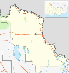
Narrung is a locality located in the local government area of the Rural City of Swan Hill in Victoria, Australia. Narrung post office opened in 1902 and was closed on 17 February 1969.
It was also the site of a Victorian government customs house.
References
- "2016 Narrung (Vic.), Census All persons QuickStats | Australian Bureau of Statistics". abs.gov.au. Retrieved 26 May 2022.
- Premier Postal History, Post Office List, retrieved 11 April 2008
- "The river as a highway: Steam navigation on the River Murray". SLSA. 23 July 2007.
| Localities in the Rural City of Swan Hill | ||
|---|---|---|
| City |  | |
| Town | ||
| Locality |
| |
| ^ - Territory divided with another LGA | ||
This article about a location in the Mallee is a stub. You can help Misplaced Pages by expanding it. |