Town in Ida-Viru County, Estonia
| Narva-Jõesuu | |
|---|---|
| Town | |
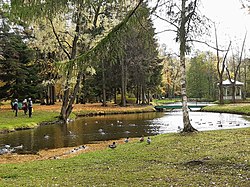
 Park in midtown Narva-Jõesuu Park in midtown Narva-Jõesuu | |
 | |
| Coordinates: 59°27′32″N 28°02′26″E / 59.45889°N 28.04056°E / 59.45889; 28.04056 | |
| Country | |
| County | |
| Municipality | |
| Area | |
| • Total | 11.03 km (4.26 sq mi) |
| Population | |
| • Total | 2,681 |
| • Rank | 31st |
| • Density | 240/km (630/sq mi) |
| Time zone | UTC+2 (EET) |
| • Summer (DST) | UTC+3 (EEST) |
Narva-Jõesuu is a seaside resort town in northeast Estonia. It is located by the Gulf of Finland of the Baltic Sea, on the west bank of the Narva River, which forms the Estonia–Russia international border.
Administratively part of the Ida-Viru County, Narva-Jõesuu officially became a separate town in 1993. It has a population of 2,681 (as of 1 January 2020).
History
The town's historical name variants in both Estonian (Narva jõe-suu) and Russian (Усть-Нарова, Ust'-Narova) literally mean 'mouth of Narva river'.
The first settlement probably arose in the first half the 14th century, when the area was ruled by the Kingdom of Denmark. After the king of Denmark sold the dominion in northern Estonia, it became part of the State of the Teutonic Order from 1346. It was first documented in a 1503 deed issued by Master of the Livonian Order Wolter von Plettenberg and was the site of an outer harbour of the city of Narva from the 16th century, containing several timber stockyards, sawmills, and small shipbuilding industry.
The Narva-Jõesuu Lighthouse was erected in 1808.
Thanks to its 8-kilometer (5.0 mi)-long white sand beach lined with pine trees – considered one of the finest in Estonia – Narva-Jõesuu has long been a popular summer destination. In the late 19th and early 20th century it was a spa town frequented by the nobility from Saint Petersburg, which is less than 150 km (93 mi) to the east, and from Moscow. During the Soviet period, it was visited in large numbers by residents of Saint Petersburg (then Leningrad), particularly the Soviet "apparatchiks" and intelligentsia, many of whom built a dacha (Russian: 'summer house') in Narva-Jõesuu or on the outskirts.
In the 1990s, after the restoration of Estonia's independence, Narva-Jõesuu saw few foreign visitors from Russia or elsewhere, and as a result, many hotels and guest houses went out of business. In the 21st century, the town's resort facilities have been renovated, and the number of tourists has an upward trend. However, the number of hotels is still considerably lower compared to the late 1980s.
Narva-Jõesuu marks the northeastern terminus of the E9 European Coastal Path, which runs for 5000 km (3125 miles) from Cabo de São Vicente in Portugal.
Demographics
Narva-Jõesuu has a population of 2,681 (as of 1 January 2020). As in the nearby city of Narva, most residents today are Russian or Russian-speaking, although the percentage of native Estonians is slightly higher in Narva-Jõesuu (13% compared to 4% in Narva).
Gallery
-
 Ruins of Narva-Jõesuu kuursaal (resort hall)
-
Pier in the mouth of Narva River
-
 Narva-Jõesuu Lighthouse
-
 Park in the town centre
-
 Beach life
-
The beach and the lighthouse
Notes
- Estonian pronunciation: [ˈnɑrʋɑ-ˈjɤesuː]
- Historical names include German: Hungerburg, Narwa-Mündung; Russian: Усть-Нарва, Усть-Нарова, Ust'-Narva, Ust'-Narova
References
- Population by sex, age and place of residence after the 2017 administrative reform, 1 January. Statistics Estonia.
- ^ "Population figure and composition". Statistics Estonia. Retrieved 24 May 2010.
External links
| Cities and towns of Estonia | ||
|---|---|---|
| ||
| Jaanilinn (Ivangorod) and Petseri (Pechory) were annexed by the Soviet Union in 1945 and are currently part of Russia. | ||
| Settlements in Narva-Jõesuu (urban municipality) | ||
|---|---|---|
| Town |  | |
| Small boroughs | ||
| Villages | ||