Suburb of Shire of Paroo, Queensland, Australia
| Nebine Queensland | |||||||||||||||
|---|---|---|---|---|---|---|---|---|---|---|---|---|---|---|---|
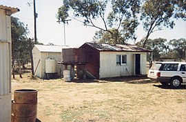
 Nebine Library, 1990 Nebine Library, 1990 | |||||||||||||||
 | |||||||||||||||
| Coordinates | 28°03′52″S 146°48′51″E / 28.0645°S 146.8142°E / -28.0645; 146.8142 (Nebine (centre of locality)) | ||||||||||||||
| Population | 29 (2021 census) | ||||||||||||||
| • Density | 0.00634/km (0.01643/sq mi) | ||||||||||||||
| Postcode(s) | 4488 | ||||||||||||||
| Area | 4,571.1 km (1,764.9 sq mi) | ||||||||||||||
| Time zone | AEST (UTC+10:00) | ||||||||||||||
| LGA(s) | Shire of Paroo | ||||||||||||||
| State electorate(s) | Warrego | ||||||||||||||
| Federal division(s) | Maranoa | ||||||||||||||
| |||||||||||||||
Nebine is a rural locality in the Shire of Paroo, Queensland, Australia. In the 2021 census, Nebine had a population of 29 people.
Geography
The Balonne Highway passes from east to west through the centre of the locality with a junction to the Balonne Charleville Road which exits the locality in the north.
The locality is flat (about 190 metres above sea level). Nebine Creek flows from north to south through the locality.
History
The locality was officially named and bounded by the Minister for Natural Resources and Minister for Mines 20 July 2001.
Demographics
In the 2016 census, Nebine had a population of 19 people.
In the 2021 census, Nebine had a population of 29 people.
References
- ^ Australian Bureau of Statistics (28 June 2022). "Nebine (SAL)". 2021 Census QuickStats. Retrieved 28 February 2023.

- ^ "Nebine – locality in Shire of Paroo (entry 42659)". Queensland Place Names. Queensland Government. Retrieved 28 December 2020.
- ^ "Queensland Globe". State of Queensland. Retrieved 30 July 2017.
- Australian Bureau of Statistics (27 June 2017). "Nebine (SSC)". 2016 Census QuickStats. Retrieved 20 October 2018.

External links
![]() Media related to Nebine, Queensland at Wikimedia Commons
Media related to Nebine, Queensland at Wikimedia Commons
| Towns and localities in the Shire of Paroo, Queensland | |
|---|---|
| Main Article: Local government areas of Queensland |