| This article includes a list of references, related reading, or external links, but its sources remain unclear because it lacks inline citations. Please help improve this article by introducing more precise citations. (May 2024) (Learn how and when to remove this message) |
| Nesselwängle | |
|---|---|
| Municipality | |
 | |
 Coat of arms Coat of arms | |
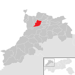
 Location within Reutte district Location within Reutte district | |
 | |
| Coordinates: 47°29′00″N 10°37′00″E / 47.48333°N 10.61667°E / 47.48333; 10.61667 | |
| Country | Austria |
| State | Tyrol |
| District | Reutte |
| Government | |
| • Mayor | Klaus Hornstein |
| Area | |
| • Total | 23.02 km (8.89 sq mi) |
| Elevation | 1,136 m (3,727 ft) |
| Population | |
| • Total | 455 |
| • Density | 20/km (51/sq mi) |
| Time zone | UTC+1 (CET) |
| • Summer (DST) | UTC+2 (CEST) |
| Postal code | 6672 |
| Area code | 05675 |
| Vehicle registration | RE |
Nesselwängle is a municipality in the district of Reutte in the Austrian state of Tyrol.
Geography
Nesselwängle lies at the entrance to the Tannheim Valley.
References
- "Dauersiedlungsraum der Gemeinden Politischen Bezirke und Bundesländer - Gebietsstand 1.1.2018". Statistics Austria. Retrieved 10 March 2019.
- "Einwohnerzahl 1.1.2018 nach Gemeinden mit Status, Gebietsstand 1.1.2018". Statistics Austria. Retrieved 9 March 2019.
External links
- Official website (in German)
- Website of the skiing area Nesselwängle (in German)
This Tyrol location article is a stub. You can help Misplaced Pages by expanding it. |