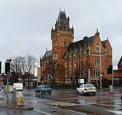
| Ellen Wilkinson High School | |
|---|---|
 Ellen Wilkinson High School Ellen Wilkinson High School | |
| General information | |
| Architectural style | Flemish Gothic |
| Year(s) built | 1878–1880 |
| Design and construction | |
| Architect(s) | Thomas Worthington |
| Designations | |
| Listed Building – Grade II* | |
| Official name | Former Nicholls Hospital including gymnasium, governor's house, stone setted and flagged forecourt, boundary walls and gates, stone gate piers on Ford Street and Devonshire Street, and two granite memorials in the forecourt |
| Designated | 2 October 1974 |
| Reference no. | 1291812 |
Ellen Wilkinson High School was housed, until it closed in 2000, in a Grade II* listed building in Ardwick, Manchester, England, designed in 1865–67 by the prolific Manchester architect Thomas Worthington. Formerly known as Nicholls Hospital, the building was funded by Benjamin Nicholls as a memorial to his son, John Ashton Nicholls. Nicholls commissioned Worthington to prepare designs, with instructions that building was only to commence after his own death. It was built in 1878–1880 and Worthington's last significant commission in the city. The original usage was as an orphanage; the Ashton family gave over £100,000 to its construction and endowment.
The style is flamboyant Flemish Gothic in red brick with sandstone dressings and steeply-pitched slate roofs. The main range is double-pile with 11 bays and a massive central tower, which shows clear similarities to that of Worthington's City Police Courts at Minshull Street. The tower was originally embellished by Worthington's trade-mark animal carving but the majority were removed in the 20th century.
From 1952 to 1967, the building was used as the Nicholls Secondary Boys School. The school later amalgamated with Ardwick High School. Initially the school was known as Nicholls Ardwick High School but was later renamed in honour of Ellen Wilkinson, socialist, feminist and first female Minister for Education, who was born in Ardwick. The school achieved renown because of its heavy emphasis on the arts, thereby anticipating 'specialist school' status by some decades. In 2000 the building changed use again when Ellen Wilkinson High School was merged into Cedar Mount High School, with the old hospital becoming Nicholls Campus of Manchester City College.
See also
References
- ^ "Former Nicholls Hospital including gymnasium, governor's house, stone setted and flagged forecourt, boundary walls and gates, stone gate piers on Ford Street and Devonshire Street, and two granite memorials in the forecourt". historicengland.org.uk. Historic England. Retrieved 16 February 2024.
- "Ellen Wilkinson High School - Manchester - Manchester - England". British Listed Buildings. 2 October 1974. Retrieved 25 January 2017.
- Nicholas Pevsner, Clare Hartwell & Matthew Hyde, The Buildings of England, Lancashire: Manchester and the South East (2004), Yale University Press
- ^ Clare Hartwell, Pevsner's Architectural Guides: Manchester (2001), Yale University Press
- "Nicholls, John Ashton" . Dictionary of National Biography. London: Smith, Elder & Co. 1885–1900.
- "The Nicholls Secondary Boys School". Manchesterhistory.net. Retrieved 25 January 2017.
- "Nicholl's Campus of City College - The former Nicholl's Hospital". Manchesterhistory.net. 1 September 1967. Retrieved 25 January 2017.
53°28′09″N 2°12′59″W / 53.4692°N 2.2165°W / 53.4692; -2.2165
Categories:- Defunct schools in Manchester
- Buildings and structures completed in 1880
- Towers in Greater Manchester
- Grade II* listed buildings in Manchester
- Grade II* listed educational buildings
- Educational institutions established in 1880
- Educational institutions disestablished in 2000
- 1880 establishments in England
- 2000 disestablishments in England
- Gothic Revival architecture in Greater Manchester
- Victorian architecture in England


