| Nikita Нікіта | |
|---|---|
| Urban-type settlement | |
 | |
| Coordinates: 44°30′40″N 34°14′7″E / 44.51111°N 34.23528°E / 44.51111; 34.23528 | |
| Republic | Crimea |
| Municipality | Yalta Municipality |
| Local council | Massandra |
| Elevation | 250 m (820 ft) |
| Population | |
| • Total | 2,257 |
| Time zone | UTC+4 (MSK) |
| Postal code | 98648, 98649 |
| Area code | +380-654 |
| Former name | Botanicheskoye (1971—1991) |
| Climate | Cfb |
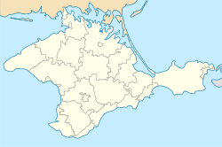
Nikita (Ukrainian: Нікіта; Russian: Никита; Crimean Tatar: Nikita) is an urban-type settlement in Yalta Municipality of the Autonomous Republic of Crimea, a territory recognized by a majority of countries as part of Ukraine and incorporated by Russia as the Republic of Crimea. It is known for the Nikitsky Botanical Garden named after the settlement. Population: 2,257 (2014 Census).
Originally it was a village of Nikita owned by a landowner Smirnov, bought by the state in 1811 for the creation of the botanical garden. During the times of the Soviet Union the settlement was renamed into Botanicheskoye ("Botanical" in Russian). The name was restored after the dissolution of the Soviet Union.
References
- Russian Federal State Statistics Service (2014). "Таблица 1.3. Численность населения Крымского федерального округа, городских округов, муниципальных районов, городских и сельских поселений" [Table 1.3. Population of Crimean Federal District, Its Urban Okrugs, Municipal Districts, Urban and Rural Settlements]. Федеральное статистическое наблюдение «Перепись населения в Крымском федеральном округе». ("Population Census in Crimean Federal District" Federal Statistical Examination) (in Russian). Federal State Statistics Service. Retrieved January 4, 2016.
External links
 Media related to Category:Nikita at Wikimedia Commons
| Administrative center: Yalta | ||
| Cities | ||
| Rural settlements | ||
| Villages | ||
This article about a location in Crimea is a stub. You can help Misplaced Pages by expanding it. |
