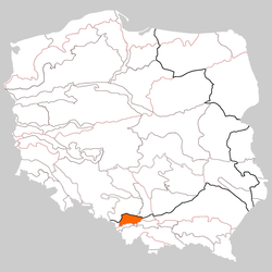
Oświęcim Basin (Polish: Kotlina Oświęcimska) is a lowland, located in southern Poland, between the Lesser Poland Highlands to the north, Silesian Foothills and Wieliczka Foothills [pl] to the south. It has the size of around 1,236 km (477 sq mi). Its name comes from the city of Oświęcim. It is located on the Vistula River on the confluences of Biała, Soła and Skawa which begin in Carpathian Mountains and Przemsza which begins in Silesian Highlands.
References
- Prof. Jerzy Kondracki. Geografia fizyczna Polski. Państwowe Wydawnictwo Naukowe. Warszawa. 1988. ISBN 83-01-02323-6
50°2′N 19°10′E / 50.033°N 19.167°E / 50.033; 19.167
This Silesian Voivodeship location article is a stub. You can help Misplaced Pages by expanding it. |
This Lesser Poland Voivodeship location article is a stub. You can help Misplaced Pages by expanding it. |