Township in Indiana, United States
| Oak Grove Township | |
|---|---|
| Township | |
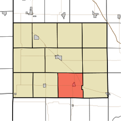
 Location of Oak Grove Township in Benton County Location of Oak Grove Township in Benton County | |
| Coordinates: 40°31′09″N 87°15′54″W / 40.51917°N 87.26500°W / 40.51917; -87.26500 | |
| Country | United States |
| State | Indiana |
| County | Benton |
| Organized | July 1840 |
| Government | |
| • Type | Indiana township |
| Area | |
| • Total | 35.53 sq mi (92.0 km) |
| • Land | 35.51 sq mi (92.0 km) |
| • Water | 0.02 sq mi (0.05 km) |
| Elevation | 748 ft (228 m) |
| Population | |
| • Total | 1,551 |
| • Density | 43.6/sq mi (16.8/km) |
| Time zone | UTC-5 (EST) |
| • Summer (DST) | UTC-4 (EDT) |
| FIPS code | 18-55620 |
| GNIS feature ID | 453681 |
Oak Grove Township is one of eleven townships in Benton County, Indiana. As of the 2020 census, its population was 1,551 and it contained 690 housing units. It was one of the first three townships originally created by the county's commissioners in 1840. It takes its name from White Oak Grove which grew southwest of Oxford.
| Census | Pop. | Note | %± |
|---|---|---|---|
| 1890 | 1,495 | — | |
| 1900 | 1,675 | 12.0% | |
| 1910 | 1,603 | −4.3% | |
| 1920 | 1,522 | −5.1% | |
| 1930 | 1,430 | −6.0% | |
| 1940 | 1,220 | −14.7% | |
| 1950 | 1,410 | 15.6% | |
| 1960 | 1,621 | 15.0% | |
| 1970 | 1,629 | 0.5% | |
| 1980 | 1,810 | 11.1% | |
| 1990 | 1,641 | −9.3% | |
| 2000 | 1,694 | 3.2% | |
| 2010 | 1,581 | −6.7% | |
| 2020 | 1,551 | −1.9% | |
| Source: US Decennial Census | |||
Geography
According to the 2020 census, the township has a total area of 35.53 square miles (92.0 km), of which 35.51 square miles (92.0 km) (or 99.94%) is land and 0.02 square miles (0.052 km) (or 0.06%) is water.
Cities and towns
Unincorporated towns
Adjacent townships
- Bolivar (east)
- Center (north)
- Grant (west)
- Pine (northeast)
- Adams Township, Warren County (southeast)
- Pine Township, Warren County (southwest)
Major highways
Cemeteries
The township contains two cemeteries: Justus and Oxford.
References
Citations
- "US Board on Geographic Names". United States Geological Survey. October 25, 2007. Retrieved January 31, 2008.
- "U.S. Census website". United States Census Bureau. Retrieved January 31, 2008.
- ^ "Explore Census Data". US Census Bureau. Retrieved February 18, 2022.
- Birch, Jesse Setlington (1942) . History of Benton County and Historic Oxford. Oxford, Indiana: Craw & Craw, Inc. p. 20.
- Andreas, Alfred Theodore (1876). "Benton County". Illustrated Historical Atlas of the State of Indiana. Chicago: Baskin, Forster & Company.
- "Township Census Counts: STATS Indiana".
Sources
External links
| Municipalities and communities of Benton County, Indiana, United States | ||
|---|---|---|
| County seat: Fowler | ||
| Towns | ||
| Townships | ||
| CDPs | ||
| Other communities |
| |
| Ghost towns | ||
| Footnotes | ‡This populated place also has portions in an adjacent county or counties | |
