| Oca–Ancón Fault System | |
|---|---|
| Falla Oca-Ancón | |
 | |
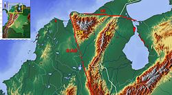
 Topographic map of northern Colombia showing the Oca Fault segment Topographic map of northern Colombia showing the Oca Fault segment | |
| Location | Northern South America |
| Coordinates | 11°00′N 71°45′W / 11.000°N 71.750°W / 11.000; -71.750 |
| Country | |
| Region | Caribbean |
| State | La Guajira Falcón, Zulia |
| Cities | Maracaibo |
| Characteristics | |
| Range | Sierra Nevada de Santa Marta, Serranía del Perijá, Venezuelan Coastal Range |
| Part of | Andean faults |
| Segments | Oca, Ancón |
| Length | 830 km (520 mi) |
| Strike | 275 ± 7 (W-E) |
| Dip angle | Vertical to subvertical |
| Displacement | 0.2–2 mm (0.0079–0.0787 in)/yr |
| Tectonics | |
| Plate | South American |
| Status | Active |
| Earthquakes | 1834 |
| Type | Strike-slip fault |
| Movement | Dextral |
| Age | Late Pleistocene-Holocene |
| Orogeny | Andean |
The Oca–Ancón Fault System (Spanish: Falla Oca-Ancón) is a complex of geological faults located in northeastern Colombia and northwestern Venezuela near the Caribbean Sea. The fault system is of right-lateral strike-slip type and extends for an approximate length of 830 km (520 mi). The Oca–Ancón Fault System is part of the diffuse boundary between the Caribbean plate and the South American plate. The movement rate of the Oca–Ancón Fault System is estimated at 2 millimetres (0.079 in) each year, more than most Venezuelan faults.
Oca fault segment
The vertical to subvertical Oca fault segment in the western part of the fault system has a length of 265 kilometres (165 mi), running west–east through La Guajira, Colombia. It forms the northern boundary of the Sierra Nevada de Santa Marta and cuts through the Serranía del Perijá continuing into Venezuela. The fault segment with a slip rate of 0.2 to 0.8 millimetres (0.0079 to 0.0315 in) per year has been active since the Late Pleistocene (~15,000 years ago) and its most recent activity has been registered in 1834.
References
Bibliography
- Audemard M., Franck A.; Singer P., André; Soulas, Jean-Pierre (2006), "Quaternary faults and stress regime of Venezuela" (PDF), Revista de la Asociación Geológica Argentina, 61 (4), Asociación Geológica Argentina: 480–491, retrieved 2015-11-24
- Audemard M., Franck A.; Singer P., André (1996a), "Active fault recognition in northwestern Venezuela and its seismogenic characterization: Neotectonic and paleoseismic approach", Geofísica Internacional, 35 (3): 245–255, doi:10.22201/igeof.00167169p.1996.35.3.460
- Audemard M., Franck A. (1996b), "Paleoseismicity studies on the Oca-Ancón fault system, northwestern Venezuela", Tectonophysics, 259 (1–3): 67–80, doi:10.1016/0040-1951(95)00144-1
- Paris, Gabriel; Machette, Michael N.; Dart, Richard L.; Haller, Kathleen M. (2000), Map and Database of Quaternary Faults and Folds in Colombia and its Offshore Regions (PDF), USGS, pp. 1–66, retrieved 2017-06-20
| Major South American geological features | |||||
|---|---|---|---|---|---|
| Tectonic plates |  | ||||
| Cratons and shields | |||||
| Structures undergoing subduction | |||||
| Faults and shear zones | |||||
| Rifts and grabens | |||||
| Sedimentary basins | |||||
| Orogenies | |||||
| Metallogenetic provinces | |||||
| Volcanism |
| ||||
| Tectonism in Colombia | |||||||||||
|---|---|---|---|---|---|---|---|---|---|---|---|
| Tectonic plates |    | ||||||||||
| Terranes | |||||||||||
| Terrane-bounding fault systems |
| ||||||||||
| Intraterrane faults |
| ||||||||||
| Major earthquakes | |||||||||||
| Orogenies | |||||||||||
| Other topics | |||||||||||
| Sources | Paris, Gabriel; Machette, Michael N.; Dart, Richard L.; Haller, Kathleen M. (2000). Map and Database of Quaternary Faults and Folds in Colombia and its Offshore Regions (PDF). USGS. pp. 1–66. Retrieved 2017-06-20.
Gómez Tapias, Jorge; Montes Ramírez, Nohora E.; Almanza Meléndez, María F.; Alcárcel Gutiérrez, Fernando A.; Madrid Montoya, César A.; Diederix, Hans (2015). Geological Map of Colombia. Servicio Geológico Colombiano. pp. 1–212. Retrieved 2019-10-29. Various authors (2014). Enciclopedia de desastres naturales históricos de Colombia (PDF). Universidad del Quindío. pp. 1–21. Retrieved 2017-06-20. | ||||||||||