| This article lacks inline citations besides NRIS, a database which provides minimal and sometimes ambiguous information. Please help ensure the accuracy of the information in this article by providing inline citations to additional reliable sources. (November 2013) (Learn how and when to remove this message) |
| Ocala Historic Commercial District | |
| U.S. National Register of Historic Places | |
| U.S. Historic district | |
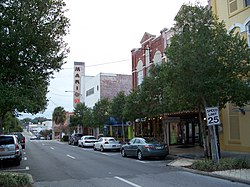
 View down Magnolia Avenue toward center of district View down Magnolia Avenue toward center of district | |
  | |
| Location | Ocala, Florida |
|---|---|
| Coordinates | 29°11′8″N 82°8′12″W / 29.18556°N 82.13667°W / 29.18556; -82.13667 |
| Area | 9 acres (36,000 m) |
| NRHP reference No. | 99000656 |
| Added to NRHP | June 3, 1999 |
The Ocala Historic Commercial District is a U.S. Historic District (designated as such on June 3, 1999) located in Ocala, Florida. It encompasses approximately 90 acres (360,000 m), and is bounded by 1st Street Northwest, 1st Avenue Southeast, 2nd Street Southwest, and 1st Avenue Southwest. It contains 20 historic buildings.
References
- "National Register Information System". National Register of Historic Places. National Park Service. July 9, 2010.
This article about a property in Marion County, Florida on the National Register of Historic Places is a stub. You can help Misplaced Pages by expanding it. |