| Oirase おいらせ町 | |
|---|---|
| Town | |
 Oirase Town Hall Oirase Town Hall | |
 Flag Flag Seal Seal | |
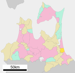
| Location of Oirase in Aomori Prefecture | |
 | |
 | |
| Coordinates: 40°35′57″N 141°23′51.8″E / 40.59917°N 141.397722°E / 40.59917; 141.397722 | |
| Country | Japan |
| Region | Tōhoku |
| Prefecture | Aomori |
| District | Kamikita |
| Area | |
| • Total | 71.96 km (27.78 sq mi) |
| Population | |
| • Total | 25,225 |
| • Density | 350/km (910/sq mi) |
| Time zone | UTC+9 (Japan Standard Time) |
| Phone number | 0178-56-2111 |
| Address | Naka-Shimoda 135-2, Oirase-machi, Kitakami-gun, Aomori-ken 039-2192 |
| Website | Official website |
| Symbols | |
| Bird | Swan |
| Flower | Sakura |
| Mascot | Oira-kun |
| Tree | Ginkgo biloba |
Oirase (おいらせ町, Oirase-chō) is a town located in Aomori Prefecture, Japan. As of 31 January 2023, the town had an estimated population of 25,225 in 10789 households, and a population density of 350 persons per km². The total area of the town is 71.96 square kilometres (27.78 sq mi).
Geography
Oirase is located on the eastern coastline of Aomori Prefecture, facing the Pacific Ocean. The land is mostly flat or slightly hilly. The Oirase River, which is the origin of the town's name, flows from west to east, with Lake Towada as its source.
Neighbouring municipalities
Aomori Prefecture
Climate
The town has a cold maritime climate characterized by cool short summers and long cold winters with heavy snowfall (Köppen climate classification Cfa). The average annual temperature in Oirase is 10.2 °C. The average annual rainfall is 1158 mm with September as the wettest month. The temperatures are highest on average in August, at around 22.8 °C, and lowest in January, at around -1.6 °C.
Demographics
Per Japanese census data, the population of Oirase has steadily increased over the past 40 years.
| Year | Pop. | ±% p.a. | ||
|---|---|---|---|---|
| 1950 | 15,958 | — | ||
| 1960 | 17,709 | +1.05% | ||
| 1970 | 17,036 | −0.39% | ||
| 1980 | 17,637 | +0.35% | ||
| 1990 | 19,120 | +0.81% | ||
| 2000 | 23,220 | +1.96% | ||
| 2010 | 24,188 | +0.41% | ||
| 2020 | 24,273 | +0.04% | ||
| ||||
History
During the Edo period, the area around Oirase was controlled by the Nambu clan of Morioka Domain, becoming part of the territories of Shichinohe Domain in the latter half of the Edo period. In the post-Meiji Restoration establishment of the modern municipalities system on 1 April 1889, the villages of Momoishi and Shimoda were created. Monoishi was elevated to town status on April 20, 1929 and Shimoda on August 1, 1969. The town of Oirase was established by the merger of the former towns of Momoishi and Shimoda, on March 1, 2006. The town was named after the Oirase River.
Government
Oirase has a mayor-council form of government with a directly elected mayor and a unicameral town council of 16 members. Oirase is part of Kamikita District which contributes four members to the Aomori Prefectural Assembly. In terms of national politics, the town is part of Aomori 2nd district of the lower house of the Diet of Japan.
Economy
The economy of Oirase is heavily dependent on agriculture, with main crops including rice, strawberries, Japanese yam and carrots. The town has become commercially more vibrant with the construction of AEON Group, Jusco Shopping center in 1995 and the spin-off retailing this has attracted. The major local industry is Momokawa Brewing, Inc, a nationally-known sake brewer. Oirase also serves as a bedroom community for the nearby cities of Misawa and Hachinohe.
Education
Oirase has five public elementary schools and three public middle schools operated by the town government. The town has one public high school operated by the Aomori Prefectural Board of Education.
Transportation
Railway
![]() Aoimori Railway Company - Aoimori Railway Line
Aoimori Railway Company - Aoimori Railway Line
Highway
Local attractions
- Akōbō Kofun Cluster, a Kofun period National Historic Site
Noted people from Oirase
- Shingo Mimura, politician
References
- "Oirase town official statistics" (in Japanese). Japan.
- Oirase climate data
- Oirase population statistics
- Akōbō Kofun Cluster. Agency for Cultural Affairs (in Japanese)
External links
![]() Media related to Oirase, Aomori at Wikimedia Commons
Media related to Oirase, Aomori at Wikimedia Commons
- Official Website (in Japanese)
| Aomori (capital) | ||
| Core cities | ||
| Cities | ||
| Districts | ||
| List of mergers in Aomori Prefecture | ||