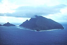
Olosega County is a county in the Manu'a District in American Samoa. It was the result of the subdivision of the prior Luanuu County in two, with the other newly created county being Ofu, first reported on the 1930 U.S. Census. It contains the two villages of Olosega and Sili.
The name of the county, Olosega, is derived from the Samoan language and translates into English as “Fortress of Parakeets".
Demographics
| Year | Pop. | ±% |
|---|---|---|
| 1930 | 438 | — |
| 1940 | 509 | +16.2% |
| 1950 | 545 | +7.1% |
| 1960 | 429 | −21.3% |
| 1970 | 380 | −11.4% |
| 1980 | 249 | −34.5% |
| 1990 | 225 | −9.6% |
| 2000 | 216 | −4.0% |
| 2010 | 177 | −18.1% |
| 2020 | 147 | −16.9% |
| U.S. Decennial Census | ||
Olosega County was first recorded beginning with the 1930 U.S. Census. It had previously been within Luanuu County. Its population zenith was in 1950 with 545 residents and has since declined to just 177 residents as of 2010.
Villages
References
- "CPH-T-8. Population, Housing Units, Land Area, and Density for U.S. Island Areas: 2010" (PDF). United States Census. Retrieved 4 February 2019.
- 1987 Census of Agriculture: Geographic area series, Parts 55-56. Bureau of the Census. 1991. p. 4.
- "5.0102 Division of districts into counties". www.asbar.org. Archived from the original on 2014-10-08. Retrieved 2019-05-27.
- Churchill, W. (1913). "Geographical Nomenclature of American Samoa". Bulletin of the American Geographical Society, 45(3), page 192. Retrieved on December 6, 2024, from https://doi.org/10.2307/199273.
- "U.S. Decennial Census". Census.gov. Retrieved June 6, 2013.
- "American Samoa" (PDF). US Census Bureau. Retrieved 5 July 2022.
14°10′36.39″S 169°37′26.79″W / 14.1767750°S 169.6241083°W / -14.1767750; -169.6241083
| Counties of American Samoa | |
|---|---|
| Unorganized areas: Rose Atoll (Motu O Manu), Swains Island (Olohega) | |
| Defunct Counties: East Vaifanua, Luanuu, West Vaifanua |
This American Samoa location article is a stub. You can help Misplaced Pages by expanding it. |