| Oniore Waterfall and Toba First Cave Natural Monuments | |
|---|---|
| IUCN category III (natural monument or feature) | |
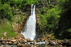
 Oniore Waterfall Oniore Waterfall | |
  | |
| Nearest city | Martvili |
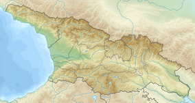
| Coordinates | 42°28.643′N 42°27.520′E / 42.477383°N 42.458667°E / 42.477383; 42.458667 |
| Area | 0.33 km (0.13 sq mi) |
| Governing body | Agency of Protected Areas |
| Website | ონიორის ჩანჩქერისა და ტობის პირველი მღვიმის ბუნები ძეგლები |
Oniore Waterfall and Toba First Cave Natural Monuments (Georgian: ოჩხომურის ჩანჩქერის ბუნების ძეგლი) is a combination of waterfall and cave at 680 m above sea level in Martvili Municipality, Samegrelo-Zemo Svaneti region of Georgia.
The cave is produced in the limestone. The excavation measured 12m X 5 m is opened along the shaft. The underground waterfall is about 70 m from the cave entrance, where the height of the ceiling is 30 meters. The width of the tunnel is 12-15 m. The waterfall is about 67 m high.

See also
References
- "Oniore Waterfall and The First Cave of Toba in Georgia". Protected Planet. Retrieved 2018-11-01.
This Georgia location article is a stub. You can help Misplaced Pages by expanding it. |