| Oranienbaum-Wörlitz | |
|---|---|
| Town | |
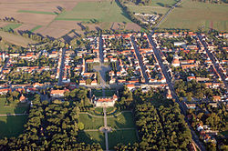
 View over Oranienbaum View over Oranienbaum | |
 Coat of arms Coat of arms | |
Location of Oranienbaum-Wörlitz within Wittenberg district
 | |
  | |
| Coordinates: 51°47′57″N 12°24′25″E / 51.79917°N 12.40694°E / 51.79917; 12.40694 | |
| Country | Germany |
| State | Saxony-Anhalt |
| District | Wittenberg |
| Government | |
| • Mayor (2017–24) | Maik Strömer (CDU) |
| Area | |
| • Total | 115.16 km (44.46 sq mi) |
| Elevation | 64 m (210 ft) |
| Population | |
| • Total | 8,067 |
| • Density | 70/km (180/sq mi) |
| Time zone | UTC+01:00 (CET) |
| • Summer (DST) | UTC+02:00 (CEST) |
| Postal codes | 06785, 06786 |
| Dialling codes | 034904, 034905 |
| Vehicle registration | WB |
| Website | www |
Oranienbaum-Wörlitz is a town in the district of Wittenberg, in Saxony-Anhalt, Germany. It was formed on 1 January 2011 by the merger of the former towns Oranienbaum and Wörlitz and the former municipalities Brandhorst, Gohrau, Griesen, Horstdorf, Kakau, Rehsen, Riesigk and Vockerode. These former municipalities are now Ortschaften (municipal divisions) of the town Oranienbaum-Wörlitz.
-
 Oranienbaum castle
-
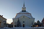
 Church Oranienbaum
-
 The Dessau-Wörlitz Garden Realm
-
Wörlitz market square
-
 Historic Inn „Zum Eichenkranz“ in Wörlitz
-
 Church of Vockerode
References
- Bürgermeisterwahlen in den Gemeinden, Endgültige Ergebnisse, Statistisches Landesamt Sachsen-Anhalt, accessed 8 July 2021.
- "Bevölkerung der Gemeinden – Stand: 31. Dezember 2022" (PDF) (in German). Statistisches Landesamt Sachsen-Anhalt. June 2023.
- Gebietsänderungen vom 01. Januar bis 31. Dezember 2011, Statistisches Bundesamt.
- Hauptsatzung der Stadt Oranienbaum-Wörlitz, § 18, 5 February 2020.
| Towns and municipalities in the district of Wittenberg | ||
|---|---|---|
This Saxony-Anhalt location article is a stub. You can help Misplaced Pages by expanding it. |
