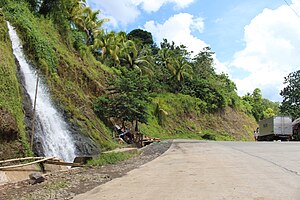
 Ozamiz–Pagadian Road
 | ||||
|---|---|---|---|---|
 Portion of the highway in Aurora-Ramon Magsaysay Border Portion of the highway in Aurora-Ramon Magsaysay Border | ||||
| Route information | ||||
| Maintained by Department of Public Works and Highways | ||||
| Length | 82 km (51 mi) | |||
| Component highways | ||||
| Major junctions | ||||
| North end | ||||
| Major intersections | ||||
| South end | ||||
| Location | ||||
| Country | Philippines | |||
| Provinces | Misamis Occidental, Zamboanga del Sur | |||
| Major cities | Ozamiz, Tangub | |||
| Towns | Bonifacio, Tambulig, Molave, Ramon Magsaysay, Aurora | |||
| Highway system | ||||
| ||||
| ||||
The Ozamiz–Pagadian Road, also known as Aurora–Ozamiz Road, is a 70-kilometer (43 mi) two-to-four lane road network connecting the cities of Ozamiz in Misamis Occidental and Pagadian in Zamboanga del Sur. It traverses through Tangub and the municipality of Bonifacio at Misamis Occidental and the municipalities of Tambulig, Molave, Ramon Magsaysay, and Aurora at Zamboanga del Sur.
The entire highway is designated as National Route 78 (N78) of the Philippine highway network.
References
- "Misamis Occidental. 1st". www.dpwh.gov.ph. Retrieved 2018-08-24.
- "Zamboanga Del Sur 1st". www.dpwh.gov.ph. Retrieved 2018-08-24.
| Transportation in the Philippines | |||||||
|---|---|---|---|---|---|---|---|
| Government | |||||||
| Road |
| ||||||
| Rail |
| ||||||
| Water | |||||||
| Aviation | |||||||
| Payment | |||||||
| Intermodal terminals | |||||||
| Related articles | |||||||
| Italics indicate defunct, proposed, or under construction. | |||||||