| This article needs additional citations for verification. Please help improve this article by adding citations to reliable sources. Unsourced material may be challenged and removed. Find sources: "Pedernales Falls State Park" – news · newspapers · books · scholar · JSTOR (October 2019) (Learn how and when to remove this message) |
| Pedernales Falls State Park | |
|---|---|
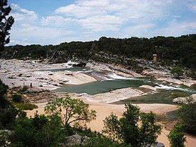
 Pedernales River running over limestone. Pedernales River running over limestone. | |
  | |
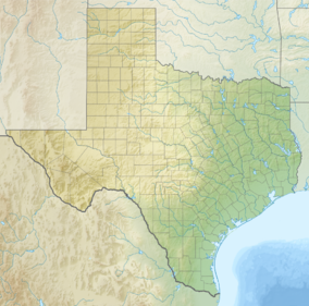
| Location | Blanco County, Texas |
| Nearest city | Johnson City |
| Coordinates | 30°18′0″N 98°14′30″W / 30.30000°N 98.24167°W / 30.30000; -98.24167 |
| Area | 5,211.7 acres (2,109 ha) |
| Established | 1971 |
| Visitors | 218,414 (in 2022) |
| Governing body | Texas Parks and Wildlife Department |
| tpwd | |
Pedernales Falls State Park (/ˌpɜːrdəˈnælɪs/ PUR-də-NAL-iss) is a 5,212-acre state park situated along the banks of the Pedernales River in Blanco County, Texas in the United States.
Location
The park is located 10 miles (16 km) east of Johnson City, and about 25 miles west of Austin, Texas.
History
Prior to the year 1970, the area that the park occupies was a working ranch, known as the Circle Bar Ranch. The state of Texas purchased the ranch in 1970, and opened the park in 1971.
Recreation
Many of the activities in Pedernales Falls State Park center around the Pedernales River: swimming, tubing, wading and fishing. The park also has a number of picnic areas and campsites, including some primitive campsites that require a hike of over two miles to reach. There are also 19.8 miles (31.9 km) of hiking and mountain biking trails, 10 miles of equestrian trails, and 14 miles of backpacking trails. There is a park store where you can purchase gift items and ice. The entrance fee is $6 daily for persons 13 years or older, children 12 and under are allowed in at no cost.
Like many rivers in central Texas, the Pedernales is prone to variable water levels. A sign at the park shows a relatively tranquil river in one picture and a raging wall of muddy water in the next picture, said to be taken only five minutes after the first. The speed at which flash floods can arise along this river has resulted in several deaths at the park.
 Panoramic view of Perdenales Falls at low water flow
Weather
| Climate data for Pedernales Falls State Park | |||||||||||||
|---|---|---|---|---|---|---|---|---|---|---|---|---|---|
| Month | Jan | Feb | Mar | Apr | May | Jun | Jul | Aug | Sep | Oct | Nov | Dec | Year |
| Record high °F (°C) | 89 (32) |
100 (38) |
102 (39) |
101 (38) |
102 (39) |
110 (43) |
108 (42) |
107 (42) |
110 (43) |
98 (37) |
93 (34) |
89 (32) |
110 (43) |
| Mean daily maximum °F (°C) | 61 (16) |
63.7 (17.6) |
71.2 (21.8) |
79.2 (26.2) |
85.2 (29.6) |
91.2 (32.9) |
94.8 (34.9) |
94.8 (34.9) |
88.8 (31.6) |
80.3 (26.8) |
70.7 (21.5) |
62.5 (16.9) |
78.6 (25.9) |
| Mean daily minimum °F (°C) | 34.8 (1.6) |
38 (3) |
46.1 (7.8) |
53.9 (12.2) |
62.4 (16.9) |
68.7 (20.4) |
70.9 (21.6) |
70.1 (21.2) |
64.3 (17.9) |
54.3 (12.4) |
45 (7) |
36.2 (2.3) |
53.7 (12.1) |
| Record low °F (°C) | 7 (−14) |
3 (−16) |
13 (−11) |
27 (−3) |
36 (2) |
50 (10) |
56 (13) |
53 (12) |
37 (3) |
22 (−6) |
17 (−8) |
1 (−17) |
1 (−17) |
| Average precipitation inches (mm) | 2.1 (53) |
2.2 (56) |
2.7 (69) |
2.3 (58) |
4 (100) |
4 (100) |
2.4 (61) |
2 (51) |
3.3 (84) |
3.9 (99) |
3.1 (79) |
2 (51) |
34 (860) |
| Average precipitation days | 3 | 3 | 3.7 | 5.6 | 6.5 | 5.3 | 4.7 | 4.1 | 5 | 4.2 | 2.9 | 3.1 | 51.1 |
| Average relative humidity (%) | 67 | 65 | 58 | 61 | 65 | 62 | 59 | 59 | 64 | 66 | 65 | 63 | 63 |
| Source: Weatherbase | |||||||||||||
Nature
The river limestone at Pedernales Falls is 300 million years old. Erosion from deposits in the Cretaceous period created the current formations.
Wildlife in the park is typical of the Texas Hill Country, including white-tailed deer, coyotes, rabbits, armadillos, wild hogs, skunks, opossums and raccoons. Many types of birds, including the endangered golden-cheeked warbler, can be found in the summer.
Trees commonly found in the area include juniper, pecan, sycamore, elm, walnut, hackberry, and others.
Venomous snakes most commonly found in the Texas Hill Country are the western diamondback rattlesnake, eastern copperhead, and the water moccasin.
See also
- Balcones Canyonlands NWR
- Barton Creek
- Central Texas
- Colorado River (Texas)
- Double Mountain Fork Brazos River
- Edwards Plateau
- Enchanted Rock
- List of Texas state parks
- Llano River
- Mount Bonnell
- Texas Hill Country
References
- Christopher Adams. "What is the most visited state park in Texas? Here's the top 10 countdown". KXAN.com. Retrieved November 21, 2023.
- https://tpwd.texas.gov/state-parks/pedernales-falls/park_history, Archived 2019-05-13 at the Wayback Machine
- "Pedernales Falls State Park — Texas Parks & Wildlife Department".
- "Pedernales Falls State Park: Monthly Weather Averages Summary". weatherbase.com. Retrieved December 13, 2020.
- "Pedernales Falls State Park Nature — Texas Parks & Wildlife Department". tpwd.texas.gov. Retrieved June 8, 2021.
- "Pedernales Falls State Park Nature — Texas Parks & Wildlife Department".
- "Venomous Snakes of the Texas Hill Country". November 22, 2017.
External links
- Pedernales Falls State Park information from the Texas Parks and Wildlife Department
- Pedernales Falls State Park from the Handbook of Texas Online
- Film footage of Pedernales Falls State Park from Exploring the Texas State Park System from the Texas Archive of the Moving Image
| Austin–Round Rock–San Marcos | |||||
|---|---|---|---|---|---|
| Central city |  | ||||
| Satellite cities | |||||
| Other communities | |||||
| Counties |
| ||||
| Parks and preserves | |||||
| Geography | |||||
| Bodies of water | |||||
| Transportation | |||||