| This article includes a list of general references, but it lacks sufficient corresponding inline citations. Please help to improve this article by introducing more precise citations. (January 2011) (Learn how and when to remove this message) |
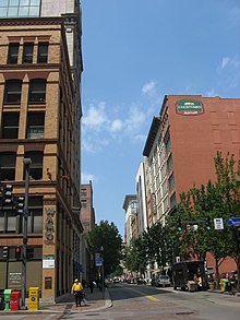
 The 900 block of Penn Avenue. The 900 block of Penn Avenue. | |
| Length | 8.7 mi (14.0 km) |
|---|---|
| Component highways |
|
| Location | Pittsburgh |
| West end | Liberty Avenue in Downtown |
| Major junctions | Stanwix Street in Downtown Fifth Avenue in Downtown |
| East end | Greensburg Pike near Wilkinsburg |
Penn Avenue is a major arterial street in Pittsburgh and Wilkinsburg, in Pennsylvania. Its western terminus lies at Gateway Center in downtown Pittsburgh. For its westernmost ten blocks it serves as the core of the Cultural District with such attractions as Heinz Hall, the Benedum Center and the Byham Theater as well as the David L. Lawrence Convention Center and the Heinz History Center bordering it. Exiting downtown it is the major route through the city's Strip District, Lawrenceville, Bloomfield, Garfield and East Liberty neighborhoods. Its eastern portion exits the city at Wilkinsburg where it continues to exist as Penn Avenue with a numbering system that begins anew using small numbers as it approaches Interstate 376 the "Parkway East". Penn Avenue is about 8.7 miles (14.0 km) long.
From downtown, Penn Avenue travels in the same general direction as the Allegheny River, thus it passes close by a number of the bridges of the city that cross that river. In the downtown area, Penn Avenue is the main bisecting street of the Three Sister Bridges that form the Roberto Clemente Bridge, Andy Warhol Bridge and Rachel Carson Bridge. It passes the 16th Street Bridge, and goes straight through the Strip District.
History
Before being named Penn Avenue it was known as the Great Road, being perhaps the only road leading from east of the Allegheny Mountains to the headwaters of the Ohio River. It may have been known as the Great Road when George Washington traveled it, in 1753. In the 18th century, settlers entered the area from the eastern part of Pennsylvania via a road which came to be called the Greensburg Pike early in the 19th century. The road passed through a tiny settlement which grew to become Greensburg, Pa. In Pittsburgh, Greensburg Pike became Penn Avenue, therefore, Penn Avenue is the oldest and most historically significant street in Pittsburgh.
Bike infrastructure
In early 2014, the City of Pittsburgh announced the installation of the first set of protected bike lanes in the area. After deliberation, it was decided that Penn Avenue would be the candidate for the lanes. The eastbound lane of Penn Avenue was removed from the David McCullough Bridge to 6th Street in Downtown to provide protected bike lanes. The lanes have provided bikers with a safe and effective way of leaving Downtown.
References
- Google Maps
- Wilkinsburg Historical Society (2007) Wilkinsburg, Arcadia Publishing, 7
- "Pittsburgh ready to roll with bike lanes".
40°26′38″N 79°56′18″W / 40.44381°N 79.93824°W / 40.44381; -79.93824
| City of Pittsburgh | |
|---|---|
| Government | |
| Economy | |
| Other topics | |