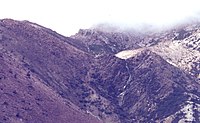
Philosophers Ridge is the long spur that connects Mount Lyell and Mount Owen in the West Coast Range of Western Tasmania.
On it are significant sites of the Mount Lyell copper field.
The original Iron Blow was on its midslopes, discovered on the ridge by Karlson and McDonough.
The North Lyell Mine, scene of the 1912 North Mount Lyell Disaster, was at its northernmost end, on the slopes of Mount Lyell. Very close to the mine was the settlement of the same name; the North Lyell tram traversed the ridge, as did the ill-fated North Lyell aerial tram. These features no longer exist due to the mining of the area, but they all had significant roles to play in the history of the Mount Lyell Mining and Railway Company.
The Gap, the point where the Queenstown to Gormanston road (originally known as the Queenstown to Gormanston Dray Road, now known as the Lyell Highway) passed over the ridge, is the southernmost named feature that remains. Down the western slope of the ridge, the Mount Lyell Haulage and the Mount Lyell aerial tram took ore from the mines that worked on the ridge to the Queenstown smelters.
The eastern slope of the ridge faced into the Linda Valley and the town of Gormanston.
Notes
- "COPPER MINING". Zeehan and Dundas Herald (Hobart, Tas. : 1890 - 1922). Hobart, Tas.: National Library of Australia. 19 May 1908. p. 2. Retrieved 28 June 2012.
- "GOLD". Launceston Examiner (Tas. : 1842 - 1899). Tas.: National Library of Australia. 20 July 1887. p. 3. Retrieved 28 June 2012.
- In the chapter Poverty Gully of The Peaks of Lyell - describes the Iron Blow feature as -the strange formation... jutted twenty or thirty feet above the surface
- "MINING". The Mount Lyell Standard And Strahan Gazette. Vol. 4, no. 530. Tasmania, Australia. 1 March 1900. p. 3. Retrieved 9 June 2022 – via National Library of Australia.
- "North Mount Lyell Aerial Tramway". The Mount Lyell Standard And Strahan Gazette. Vol. 4, no. 742. Tasmania, Australia. 5 November 1900. p. 3. Retrieved 9 June 2022 – via National Library of Australia.
- "Nrth Mount Lyell". The Mount Lyell Standard And Strahan Gazette. Vol. 4, no. 670. Tasmania, Australia. 13 August 1900. p. 4. Retrieved 9 June 2022 – via National Library of Australia.
- "GORMANSTON NOTES". The Mercury. Vol. LXXII, no. 8844. Tasmania, Australia. 6 July 1898. p. 3. Retrieved 9 June 2022 – via National Library of Australia.
- "COACH UPSET". Zeehan and Dundas Herald. Vol. XVI, no. 164. Tasmania, Australia. 26 April 1905. p. 4. Retrieved 9 June 2022 – via National Library of Australia.
- "GORMANSTON". The Advocate (Australia). Tasmania, Australia. 26 April 1932. p. 6. Retrieved 9 June 2022 – via National Library of Australia.
42°04′S 145°35′E / 42.06°S 145.58°E / -42.06; 145.58
| Western region of Tasmania, Australia | |||||||||||||
|---|---|---|---|---|---|---|---|---|---|---|---|---|---|
| Cities and other settlements | |||||||||||||
| Governance | |||||||||||||
| Mountains |
| ||||||||||||
| National parks | |||||||||||||
| Rivers | |||||||||||||
| Lakes | |||||||||||||
| Dams | |||||||||||||
| Power stations | |||||||||||||
| Transport |
| ||||||||||||
| Landmarks |
| ||||||||||||
| People of note | |||||||||||||
| Mining | |||||||||||||
| Books and newspapers | |||||||||||||
| Other | |||||||||||||