| Piastów | |
|---|---|
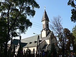
 Black Madonna of Częstochowa Church Black Madonna of Częstochowa Church | |
 Coat of arms Coat of arms | |
 | |
| Coordinates: 52°11′N 20°51′E / 52.183°N 20.850°E / 52.183; 20.850 | |
| Country | |
| Voivodeship | Masovian |
| County | Pruszków |
| Gmina | Piastów (urban gmina) |
| Established | 16th century as Żdżary |
| Town rights | 1952 |
| Government | |
| • Mayor | Grzegorz Waldemar Szuplewski |
| Area | |
| • City | 5.83 km (2.25 sq mi) |
| • Urban | 5.76 km (2.22 sq mi) |
| Population | |
| • City | 22,826 |
| • Density | 3,900/km (10,000/sq mi) |
| • Urban | 22,826 |
| • Urban density | 4,050.5/km (10,491/sq mi) |
| Time zone | UTC+1 (CET) |
| • Summer (DST) | UTC+2 (CEST) |
| Postal code | 05-820 |
| Area code | +48 22 |
| Car plates | WPR |
| Website | http://piastow.pl/ |
Piastów is a town in central Poland, near Warsaw, with 23,331 inhabitants (2006 est). It is situated in the Masovian Voivodship (since 1999); previously, it was in Warszawa Voivodship (1975–1998). With 3963 persons/km², it is the second most densely populated township in Poland (after Świętochłowice).
In the Middle Age, the villages of Żdżary and Utrata existed in the place of today's' Piastów. Piastów is served by Piastów railway station.
| Gminas of Pruszków County | ||
|---|---|---|
| Urban gminas |  | |
| Urban-rural gmina | ||
| Rural gminas | ||
This Pruszków County location article is a stub. You can help Misplaced Pages by expanding it. |