| Pic de Médécourbe | |
|---|---|
| Pic de Medacorba | |
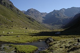
 The Vicdessos valley looking towards Pic de Médécourbe and Col de Bareytes (2859m) in the background The Vicdessos valley looking towards Pic de Médécourbe and Col de Bareytes (2859m) in the background | |
| Highest point | |
| Elevation | 2,914 m (9,560 ft) |
| Coordinates | 42°36′07″N 01°26′32″E / 42.60194°N 1.44222°E / 42.60194; 1.44222 |
| Geography | |
 | |
| Location | Andorra – France – Spain border |
| Parent range | Pyrenees |
Pic de Médécourbe (Catalan: Pic de Medacorba) is a mountain in Europe that sits on the western tripoint boundary of Andorra, France and Spain. It is 2,914 metres (9,560 ft) tall. It overlooks Étang de Soulcem, a large artificial lake used for hydroelectricity, and the Vicdessos valley.
There is also an eastern tripoint of Andorra, France, and Spain approximately 6 km south of Pas de la Casa.
References
This Andorran location article is a stub. You can help Misplaced Pages by expanding it. |
This Ariège geographical article is a stub. You can help Misplaced Pages by expanding it. |
This Spain location article is a stub. You can help Misplaced Pages by expanding it. |
- Mountains of the Pyrenees
- Mountains of Andorra
- Mountains of Occitania (administrative region)
- Mountains of Catalonia
- International mountains of Europe
- Andorra–France border
- Andorra–Spain border
- France–Spain border
- Border tripoints
- Two-thousanders of Andorra
- Two-thousanders of France
- Two-thousanders of Spain
- Landforms of Ariège (department)
- Andorra geography stubs
- Ariège (department) geography stubs
- Spain geography stubs