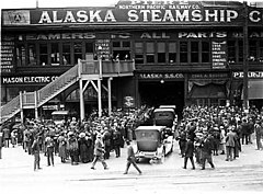
 A crowd at Pier 2. A crowd at Pier 2. | |
| Type | Shipping pier and warehouse |
|---|---|
| Locale | Seattle, Washington |
| Owner | Northern Pacific Railway |
| Characteristics | |
| Total length | 770 ft (234.7 m) |
| Width | 120 ft (36.6 m) |
| History | |
Pier 2 in Seattle, Washington (after May 1, 1944, Pier 51) was an important shipping terminal.
Location
Pier 2 was located at the foot of Yesler Way. Pier 2 was immediately to the north of Pier 1 and immediately to the south of Colman Dock.
History
Pier 21 and Pier 1 to its south were built between 1901 and 1904, replacing Yesler's Wharf. In 1904, Joshua Green's La Conner Trading, by then a subsidiary of the Puget Sound Navigation Company, was operating jointly with businessman H.B. Kennedy as the Navy Yard Route on the Seattle – Bremerton run. Disposing of three vessels, including the Inland Flyer, Athlon, and the sternwheeler Port Orchard, the Navy Yard route ran six sailings a day from Pier 2 to and from Bremerton, Washington.
In 1917, like Pier 1, Pier 2 was owned by the Northern Pacific Railway, although in the case of Pier 2 it was operated by the Alaska Steamship Company. Pier 2 measured 770 by 120 feet (235 by 37 m), with 1,400 feet (430 m) of berthing space. Pier 2 had a warehouse measuring 750 by 100 feet (229 by 30 m), with a cargo capacity of 17,000 tons. Track capacity at Pier 2 was 18 rail cars. Like Pier 1, Pier 2 had adjustable slips. In 1917 Pier 2 had an electric crane, with a capacity 25 tons.
As with Pier 1/50, Alaska Steamship Company left in the late 1940s. The pier had various uses over the next three decades. Washington State Ferries moored ships there; eventually the pier lost its shed and became mainly a parking lot. In the early 1960s, the restaurant Polynesia was built there. The pier was also home to Ye Olde Curiosity Shop., In 1971, it was owned and/or operated by Seattle Piers, Inc. and, along with Pier 1/50, was the proposed site for a World Trade Center, which was ultimately built elsewhere. The pier was torn down early 1980s to expand the Washington State Ferries terminal at Pier 52 (Colman Dock).
Notes
- Daryl C. McClary (November 26, 2011), "Seattle docks and piers are given new designations on May 1, 1944", HistoryLink, Seattle: History Ink, retrieved March 15, 2023
- ^ Beaton, Welford, ed. Frank Waterhouse & Company's Pacific Ports: A Commercial Geography (1917), at pages 27 to 37. (accessed 06-09-11)
- ^ Thomas Street History Services (November 2006). "Context Statement: The Central Waterfront" (PDF). Seattle Department of Neighborhoods. Retrieved March 15, 2023. Updated January 2007.
- Newell, ed., H.W. McCurdy Marine History, at 32, 67, 76, 87, 100, 110, 145, 175, 268, and 270.
- ^ Paul Dorpat (2005). "3" (PDF). The Seattle Waterfront: An Illustrated History. p. 198. Retrieved August 2, 2019.
- ^ "Seattle Harbor Directory". Seattle Municipal Archives. 1971. Retrieved 2022-10-18. Map also available as File:Map of Seattle Harbor, circa 1971 (52409434495).jpg.
References
- Beaton, Welford, ed. Frank Waterhouse & Company's Pacific Ports: A Commercial Geography (1917) (accessed 06-09-11).
- Newell, Gordon R., ed., H.W. McCurdy Marine History of the Pacific Northwest, Superior Publishing Co., Seattle, WA (1966)
- State of Washington, Public Utilities Comm'n, Third Annual Report (covering the period from Dec. 1, 1912 to Nov. 30, 1913), Vol. 3, at page 199. (accessed 06-09-11)
47°36′06″N 122°20′12″W / 47.60167°N 122.33667°W / 47.60167; -122.33667
Categories: