| Pinlaung Township ပင်လောင်းမြို့နယ် | |
|---|---|
| Township of Taunggyi | |
| Pinlaung Township | |
 | |
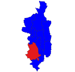
 Location in Taunggyi district Location in Taunggyi district | |
| Country | Myanmar |
| Division | |
| District | Pa-O Self-Administered Zone |
| Township | Pinlaung |
| Area | |
| • Total | 3,395 km (1,311 sq mi) |
| Population | |
| • Total | 192,257 |
| • Density | 57/km (150/sq mi) |
| Time zone | UTC6:30 (MST) |
Pinlaung Township (Burmese: ပင်လောင်းမြို့နယ်) is a township of Taunggyi District in the Shan State of Myanmar. It is one of three townships in the Pa-O Self-Administered Zone. Its principal town is Pinlaung. According to the 2014 Myanmar Population and Housing Census, there are 115,047 residents in the township.

Wildlife
Inle Lake and Inlay Lake Wetland Sanctuary, a well known tourist place and bird watching site, partly lies in this township.
This township is home to two endemic rare species of trapdoor spider, the Liphistius Birmanicus and Liphistius Lordae. After first being discovered by an American scientist in 1897, the spiders were again spotted in Pyin Oo Lwin and Taunggyi.
Economy
The township is home to the Tigyit coal-fired power plant, one of three coal-fired power plants in Myanmar.
Pinlaung Township accounts for the largest area of tea cultivation in southern Shan State. The Tea grown here is of the Assamica cultivar. Tea plantations in the area cover 12,000 acres, with half of the cultivation taking place in the higher elevations of Le Hlaung, 10 miles from Pinlaung. In the Koe Khaung ward, tea production is refined and the tea coming from the nearly 100 tea-producing households is highly sought after. Farmers here use stoves with chimneys and clean pans for roasting, which creates a smoother teat that fetches higher prices than other teas in the region.
Traditionally, farmers in Pinlaung Township made a living mostly off of poppy production, but have expressed interest in recent years of veering away from such farming and switching to substitute crops. In 2017, the Taung Yoe Ethnic Literature and Culture Association (Central) requested government assistance not only for the substitute seeds but also for pesticides in order to substitute cash crops
Infrastructure
Before 2010, accessing Pinlaung Township was as dangerous as it was difficult. Merchants from Naypyidaw,southern, and western Myanmar who wanted trade with the Shan and Pa'O farmers and ethnic tribes in the areas were required to go up and around the dangerous roads of Elephant Mountain (Sin Taung) and cross the Paung Laung River by boat. Then, Myanmar's former government contracted P.T.Waagner-Biro Indonesia together with Supreme Group of Companies to construct an expansive steel truss suspension bridge to span the river. The bridge was designed by the People’s Republic of China. The bridge, known as the Leinli Bridge, would become the highest of its kind in Myanmar. The bridge was opened on November 5, 2010, at a cost of 3.476 million in foreign currency and an additional 14,500 million kyats.
In the fiscal year 2018-2019, the Ministry of Border Affairs spent 12,055.754 million kyats from the Union budget to improve 94 roads and bridges, 62 water access works, 11 power stations, and five religious missionary programs in Pinlaung Township.
Caves
Pinlaung township is home to many large caves and cave systems. Among them are:
- Namun Spring Cave in Namun
- Road Cliff Cave in Leinli
- Banana Forrest Cave, or Nga Pyaw Thor Cave in Nam Pam
- War Lee Kwey Cavein Nam Pam
- Lower Spider Cavein Nam Pam
- Upper Spider Cavein Nam Pam
- Big Bang Cave in Tar Kge
- Buddha Head Cave in Nounbi
- Young Twint Cave in Nounbi
- Dragon Cave in Hlaings
- Te Toke Taungin Phinton
- Hti Ngut in Hti Hwali
- Namun Spring Wall Cave in Namun
- Yar Za Cave (Hti Bwar Cave) in Taung Hti Bwar
References
- "2014 Myanmar Population and Housing Census" (PDF). Retrieved 15 November 2018.
- "Inle lake wetland sanctuary - Shan state". Retrieved 13 July 2014.
- "Birdwatching in Myanmar". Retrieved 13 July 2014.
- "Tigyit Coal-fired Plant". Retrieved 14 November 2018.
- "Change Afoot in Southern Shan State". Retrieved 14 March 2019.
- "Discover Myanmar, Beauty Begins in Shan State". Retrieved 14 March 2019.
- "Growers in Shan State Want to Give up Poppy Cultivation". Retrieved 15 November 2018.
- "Discover Myanmar, Beauty Begins in Shan State". Retrieved 14 March 2019.
- "Leinli Bridge, Supreme Group of Companies" (PDF). Retrieved 14 March 2019.
- "New Tar Road opened in Pinlaung". Archived from the original on November 14, 2018. Retrieved 14 November 2018.
{{cite web}}: CS1 maint: unfit URL (link) - "Myanmar Caves" (PDF). Retrieved 15 November 2018.
- "Discover Myanmar, Beauty Begins in Shan State". Retrieved 14 March 2019.
Category:

