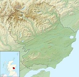
| Pitlyal Loch | |
|---|---|
| Round Loch (English) | |
 Thriepley beside Pitlyal Loch, from Lundie Craigs Thriepley beside Pitlyal Loch, from Lundie Craigs | |
 | |
| Location | NO 2997 3823 |
| Coordinates | 56°31′51″N 3°08′24″W / 56.5308°N 3.1399°W / 56.5308; -3.1399 |
| Type | Freshwater loch |
| Max. length | 0.32 km (0.20 mi) |
| Max. width | 0.22 km (0.14 mi) |
| Surface area | 5 ha (12 acres) |
| Average depth | 8.5 ft (2.6 m) |
| Max. depth | 19 ft (5.8 m) |
| Water volume | 5,347,000 cu ft (151,400 m) |
| Shore length | 1 km (0.62 mi) |
| Surface elevation | 188 m (617 ft) |
| Max. temperature | 59 °F (15 °C) |
| Min. temperature | 55 °F (13 °C) |
| Islands | 0 |
| Shore length is not a well-defined measure. | |
Pitlyal Loch also known as Round Loch is a small lochan in Sidlaw Hills in Angus. It is located southeast of Long Loch and is almost directly south of Newtyle and 5 miles (8 km) south-by-south-east of Coupar Angus.
Geography
The loch is a designated Site of Special Scientific Interest (SSSI).
See also
References
- ^ John, Murray; Lawrence, Pullar. Bathymetrical Survey of the Fresh-Water Lochs of Scotland, 1897-1909 Lochs of the Tay Basin Volume II - Pitlyal. National Library of Scotland. p. 112. Retrieved 21 September 2019.
 This article incorporates text from this source, which is in the public domain.
- ^ "Round Loch". Centre for Ecology and Hydrology. Scotland and Northern Ireland Forum for Environmental Research (SNIFFER). Retrieved 20 September 2019.
- Gittings, Bruce; Munro, David. "Pitlyal Loch". The Gazetteer for Scotland. School of GeoSciences, University of Edinburgh and The Royal Scottish Geographical Society. Retrieved 21 September 2019.
- "Round Loch of Lundie". SSSI Register. Register of Scotland. Retrieved 21 September 2019.