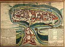
| Eyalet-i Kamaniçe | |||||||||
|---|---|---|---|---|---|---|---|---|---|
| Eyalet of the Ottoman Empire | |||||||||
| 1672–1699 | |||||||||
 The Podolia Eyalet in 1683 | |||||||||
| Capital | Kamianets-Podilskyi | ||||||||
| Area | |||||||||
| • Coordinates | 48°41′N 26°35′E / 48.683°N 26.583°E / 48.683; 26.583 | ||||||||
| History | |||||||||
| • Siege of Kamenets | 1672 | ||||||||
| • Treaty of Karlowitz | 1699 | ||||||||
| |||||||||
| Today part of | Ukraine | ||||||||
Podolia Eyalet (Ottoman Turkish: ایالتِ كامانىچه, romanized: Eyalet-i Kamaniçe) was an eyalet of the Ottoman Empire. Its capital was Kamianets-Podilskyi (Ukrainian: Кам’янець-Подільський; Polish: Kamieniec Podolski; Ottoman Turkish: كامانىچه, romanized: Kamaniçe).
History

In 1672, the Ottoman army, led by Sultan Mehmed IV, captured Kamaniçe after a short siege. The Treaty of Buchach confirmed Ottoman control of the city, which became the centre of a new eyalet. The treaty was repudiated by the Polish Diet, and war broke out anew.
The Polish campaign proved unsuccessful, and the truce of Żurawno (1676) left Podolia within Ottoman borders. Another Polish-Ottoman war broke out again in 1683. For the next 16 years, Ottoman rule in Podolia generally was limited to the blockaded fortress of Kamianets, held by a garrison of 6,000 soldiers. The other garrisons in Podolia, in Bar, Medzhybizh, Jazlivec, and Chortkiv, barely exceeded 100 soldiers each.
According to the Ottoman provincial budget of 1681, 13 million akçe were spent yearly in the eyalet, primarily for soldiers' pay. Of this amount, less than 3% was collected from Podolia itself, the rest was sent from the central treasury. In 1681, the patriarch of Constantinople appointed the Orthodox metropolitan of Kamianets, named Pankratij.
The fortress was returned to Poland as a result of the Treaty of Karlowitz (1699).
Governors

During the 27 years of Ottoman rule, Podolia was administered by nine Ottoman pashas:
- Küstendilli Halil (1672–76; 1677–80),
- Arnavut Ibrahim (1676–77)
- Defterdar Ahmed (1680–82)
- Arnavut Abdurrahman (1682–84)
- Tokatlı Mahmud (1684)
- Bozoklu Mustafa (1685–86)
- Sarı Boşnak Hüseyin (1686–88)
- Yegen Ahmed (1688–89)
- Kahraman Mustafa (1689–99)
See also
Administrative divisions
The eyalet was divided into four sanjaks:
References
- Marc David Baer (2011-09-01). Honored by the Glory of Islam: Conversion and Conquest in Ottoman Europe. Oxford University Press. p. 290. ISBN 978-0-19-979783-7. Retrieved 2013-06-03.
- ^ Agoston, Gabor; Masters, Bruce Alan (2009). Encyclopedia of the Ottoman Empire. Infobase Publishing. p. 306. ISBN 978-1-4381-1025-7. Retrieved 2013-02-25.
- ^ Kołodziejczyk, Dariusz (June 1992). "Ottoman Podillja: The Eyalet of Kamjanec, 1672-1699". Harvard Ukrainian Studies. 16 (1/2): 87–101. JSTOR 41036452.
- Kołodziejczyk, Dariusz (2006). "The "Turkish Yoke" Revisited: The Ottoman Non-Muslim Subjects Between Loyalty, Alienation, And Riot" (PDF). Acta Poloniae Historica (93): 178–195. ISSN 0001-6829.
External links
| Administrative divisions of the Ottoman Empire | |||||||||||||||||
|---|---|---|---|---|---|---|---|---|---|---|---|---|---|---|---|---|---|
| |||||||||||||||||
| |||||||||||||||||
| Historical regions in present-day Ukraine | |
|---|---|
| Geographical regions | |
| States and tribes of classical antiquity and the Early Middle Ages | |
| Principalities of Kyivan Rus' | |
| Post-Mongol era regions | |
| Polish–Lithuanian regions | |
| Ottoman provinces | |
| Cossack regions | |
| Imperial Russian regions |
|
| Austro-Hungarian provinces | |
| 20th-century regions and states |
|
| Ethno-Ukrainian regions abroad | |