| Port de Cabús | |
|---|---|
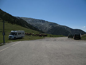
 End of the CG-4 road at Port de Cabús End of the CG-4 road at Port de Cabús | |
| Elevation | 2302 m |
| Location | La Massana, Andorra Alins, Spain |
| Range | Pyrenees |
| Coordinates | 42°32′47″N 1°25′11″E / 42.54639°N 1.41972°E / 42.54639; 1.41972 |
 | |
Port de Cabús (el. 2302 m.) is a mountain pass in the Pyrenees on the Andorran-Spanish border connecting the parish of La Massana with Alins, in Catalonia, Spain. The road is paved on the Andorran side, but not on the Spanish side.
The pass is a legal anomaly in that there are no border controls there, despite it forming the outer border of the Schengen Area, which usually features robust passport checks.
See also
External links
References
- Rutes Ciclistes d'Andorra - Ruta 9, Erts-Port de Cabús
- Xavier Basora; Jordi Romero; Xavier Sabaté (31 December 2005). "MUNTANYA DE TOR". territori.scot.cat (in Catalan). Societat Catalana d’Ordenació del Territori. Retrieved 20 July 2012.
This Andorran location article is a stub. You can help Misplaced Pages by expanding it. |
This article about a location in Catalonia is a stub. You can help Misplaced Pages by expanding it. |