| Poston Butte | |
|---|---|
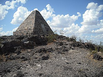
 Poston Butte, with Poston's pyramidal tomb at the peak Poston Butte, with Poston's pyramidal tomb at the peak | |
| Highest point | |
| Elevation | 1,749 ft (533 m) NAVD 88 |
| Prominence | 223 ft (68 m) |
| Coordinates | 33°03′19″N 111°24′32″W / 33.055199031°N 111.40892075°W / 33.055199031; -111.40892075 |
| Geography | |
  | |
| Location | Pinal County, Arizona, U.S. |
| Topo map | USGS Florence |
Poston Butte, formerly called Primrose Hill, is a hill located along Hunt Highway in Florence, Pinal County, Arizona, United States, near the eastern end of the Santan Mountains. Geologically, it is characterized by basalts overlying altered granite.
This hill is noted for having the pyramidal tomb of Charles Debrille Poston at its summit. Poston lobbied President Lincoln and Congress to create the Territory of Arizona and was appointed Superintendent of Indian Affairs because of his familiarity with the Native populations of the area. The tomb can be accessed by a 0.6-mile (0.97 km) trail starting from the trailhead near Hunt Highway.
References
- ^ "Poston". NGS Data Sheet. National Geodetic Survey, National Oceanic and Atmospheric Administration, United States Department of Commerce. Retrieved 2014-02-08.
- "Poston Butte AZ". ListsOfJohn.com. Retrieved 2016-08-19.
- "Poston Butte". Geographic Names Information System. United States Geological Survey, United States Department of the Interior. Retrieved 2014-02-08.
- "Poston Butte". AZGS Document Repository. Retrieved 2014-02-08.
- "Poston, Butte-Mineral, Eutte-Sacaton: Fall Field Trip" (PDF). Arizona Geological Society. November 11, 1973. Retrieved 2014-02-08.
- Poston, Charles D. "Building a State in Apache Land". p. 31. Retrieved 2014-02-08.
- Poston, Charles D. "Building a State in Apache Land". p. 32. Retrieved 2014-02-08.
- "Poston's Butte – Florence, AZ". HikeArizona.com. Retrieved 2014-02-08.

