Map all coordinates using OpenStreetMap
Download coordinates as:
Town in Queensland, Australia| Prairie Queensland | |||||||||||||||
|---|---|---|---|---|---|---|---|---|---|---|---|---|---|---|---|
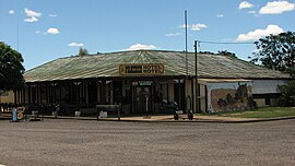
 Prairie Hotel Motel Prairie Hotel Motel | |||||||||||||||
 | |||||||||||||||
| Coordinates | 20°52′10″S 144°36′08″E / 20.8694°S 144.6022°E / -20.8694; 144.6022 (Prairie (town centre)) | ||||||||||||||
| Population | 116 (2021 census) | ||||||||||||||
| • Density | 0.01395/km (0.03612/sq mi) | ||||||||||||||
| Postcode(s) | 4821 | ||||||||||||||
| Area | 8,318.3 km (3,211.7 sq mi) | ||||||||||||||
| Time zone | AEST (UTC+10:00) | ||||||||||||||
| Location |
| ||||||||||||||
| LGA(s) | Shire of Flinders | ||||||||||||||
| State electorate(s) | Traeger | ||||||||||||||
| Federal division(s) | Kennedy | ||||||||||||||
| |||||||||||||||
Prairie is a rural town and locality in the Flinders Shire, Queensland, Australia. In the 2021 census, the locality of Prairie had a population of 116 people.
Geography
The town is located in the north of the locality. The Flinders Highway enters the locality from the north-east (Torrens Creek), passes through the town and exits to the north-west (Hughenden).
The Great Northern railway line runs parallel and immediately south of the highway, with the following railway stations (east to west):
- Warreah railway station, in the north-east of the locality (20°49′41″S 144°48′09″E / 20.8280°S 144.8026°E / -20.8280; 144.8026 (Warreah railway station))
- Karoon railway station, now abandoned (20°50′43″S 144°43′33″E / 20.8453°S 144.7258°E / -20.8453; 144.7258 (Karoon railway station (former)))
- Prairie railway station, serving the town (20°52′18″S 144°36′03″E / 20.8717°S 144.6009°E / -20.8717; 144.6009 (Prairie railway station))
- Baronta railway station, now abandoned (20°52′40″S 144°31′03″E / 20.8778°S 144.5175°E / -20.8778; 144.5175 (Baronta railway station (former)))
- Tolkuru railway station, now abandoned (20°52′33″S 144°27′13″E / 20.8757°S 144.4535°E / -20.8757; 144.4535 (Tolkuru railway station (former)))
- Tindo railway station, in the north-west of the locality (20°52′19″S 144°25′00″E / 20.8719°S 144.4166°E / -20.8719; 144.4166 (Tindo railway station))
- Jardine Valley railway station, now abandoned (20°52′10″S 144°23′25″E / 20.8694°S 144.3902°E / -20.8694; 144.3902 (Jardine Valley railway station (former)))
History
The name Prairie comes from a pastoral station established by James Gilson who named it after the appearance of the local countryside.
Prairie State School opened in 1894.
Demographics
In the 2006 census, the locality of Prairie and the surrounding area had a population of 103 people.
In the 2016 census, the locality of Prairie had a population of 143 people.
In the 2021 census, the locality of Prairie had a population of 116 people.
Education
Prairie State School is a government primary (Prep-6) school for boys and girls at Savage Street (20°52′15″S 144°36′19″E / 20.8707°S 144.6053°E / -20.8707; 144.6053 (Prairie State School)). In 2018, the school had an enrolment of 7 students with 1 teacher and 2 non-teaching staff (1 full-time equivalent).
There is no secondary school in Prairie. The nearest is Hughenden State School (to Year 12) in neighbouring Hughenden to the north-west.
Given the size of the locality, these schools will be too distant from those living in the south of the locality. Distance education or boarding schools would be options.
Amenities
The town is serviced by a hotel/motel (pub) and a cafe/post office.
References
- ^ Australian Bureau of Statistics (28 June 2022). "Prairie (SAL)". 2021 Census QuickStats. Retrieved 28 February 2023.

- "Prairie – town in Flinders Shire (entry 27449)". Queensland Place Names. Queensland Government. Retrieved 27 December 2020.
- "Prairie – locality in Flinders Shire (entry 42487)". Queensland Place Names. Queensland Government. Retrieved 27 December 2020.
- ^ "Queensland Globe". State of Queensland. Retrieved 6 March 2021.
- ^ "Railway stations and sidings - Queensland". Queensland Open Data. Queensland Government. 2 October 2020. Archived from the original on 5 October 2020. Retrieved 5 October 2020.
- ^ "Prairie – railway station in the Shire of Hughenden (entry 27451)". Queensland Place Names. Queensland Government. Retrieved 6 March 2021.
- "Tindo – rail station in Flinders Shire (entry 34626)". Queensland Place Names. Queensland Government. Retrieved 27 December 2020.
- "Flinders Shire". Queensland Places. Centre for the Government of Queensland. Archived from the original on 5 May 2012. Retrieved 22 April 2012.
- "Prairie SS". Archived from the original on 2 February 2017. Retrieved 29 January 2017.
- Australian Bureau of Statistics (25 October 2007). "Prairie (Flinders Shire) (State Suburb)". 2006 Census QuickStats. Retrieved 22 April 2012.
- Australian Bureau of Statistics (27 June 2017). "Prairie (SSC)". 2016 Census QuickStats. Retrieved 20 October 2018.

- "State and non-state school details". Queensland Government. 9 July 2018. Archived from the original on 21 November 2018. Retrieved 21 November 2018.
- "Prairie State School". Archived from the original on 18 March 2020. Retrieved 21 November 2018.
- "ACARA School Profile 2018". Australian Curriculum, Assessment and Reporting Authority. Archived from the original on 27 August 2020. Retrieved 28 January 2020.
- "Prairie". Shire of Flinders. Archived from the original on 20 April 2012. Retrieved 22 April 2012.
External links
| Towns and localities in the Shire of Flinders, Queensland | |
|---|---|
| Main article: Local government areas of Queensland |