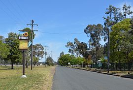
Suburb of Gunnedah Shire, New South Wales, Australia
| Premer New South Wales | |
|---|---|
 Ellerslie Street, Premer Ellerslie Street, Premer | |
 | |
| Coordinates | 31°28′S 149°54′E / 31.467°S 149.900°E / -31.467; 149.900 |
| Population | 126 (SAL 2021) |
| Postcode(s) | 2381 |
| LGA(s) | |
| State electorate(s) | |
| Federal division(s) | |
Premer is a small town in North-Western New South Wales, Australia. At the 2021 census, Premer had a population of 126 people.
Premer consists of residential houses, Premer Public School, a preschool, a caravan park, a community health centre, a Lions club, a post office, a town hall, a church, farms and a hotel.
Transport
The town formerly had a station on the Binnaway-Werris Creek railway line.
Maps
Notes and references
- Australian Bureau of Statistics (28 June 2022). "Premer (suburb and locality)". Australian Census 2021 QuickStats. Retrieved 28 June 2022.

- Australian Bureau of Statistics (28 June 2022). "Premer (suburb and locality)". 2021 Census QuickStats. Retrieved 19 May 2024.

External links
![]() Media related to Premer, New South Wales at Wikimedia Commons
Media related to Premer, New South Wales at Wikimedia Commons
| Towns and localities in the Liverpool Plains Shire local government area | |
|---|---|
| Main Article: Local government areas of New South Wales |
This New South Wales geography article is a stub. You can help Misplaced Pages by expanding it. |