| Prince Albert Prins Albert | |
|---|---|
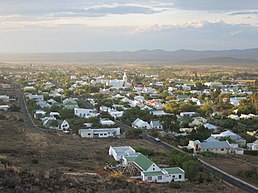
   Top: View overlooking Prince Albert. Left: the Swartberg Hotel. Right: Prince Albert Dutch Reformed Church. Top: View overlooking Prince Albert. Left: the Swartberg Hotel. Right: Prince Albert Dutch Reformed Church. | |
  | |
| Coordinates: 33°13′31″S 22°01′48″E / 33.22528°S 22.03000°E / -33.22528; 22.03000 | |
| Country | South Africa |
| Province | Western Cape |
| District | Central Karoo |
| Municipality | Prince Albert |
| Established | 1842 |
| Area | |
| • Total | 37.70 km (14.56 sq mi) |
| Population | |
| • Total | 7,054 |
| • Density | 190/km (480/sq mi) |
| Racial makeup (2011) | |
| • Black African | 2.2% |
| • Coloured | 85.7% |
| • Indian/Asian | 0.2% |
| • White | 11.3% |
| • Other | 0.6% |
| First languages (2011) | |
| • Afrikaans | 91.7% |
| • English | 4.7% |
| • Other | 3.6% |
| Time zone | UTC+2 (SAST) |
| Postal code (street) | 6930 |
| PO box | 6930 |
| Area code | 023 |
Prince Albert (Afrikaans: Prins Albert) is a small town in the Western Cape in South Africa. It is located on the southern edge of the Great Karoo, at the foot of the Swartberg mountains. In recent years the moniker the "Franschhoek of the Karoo" has been used to describe the town's appeal to the art community and wealthier South Africans, many of whom have become residents of the town.
History
Prince Albert was founded in 1762 on a farm called Queekvalleij. Originally known as Albertsburg, when it obtained municipal status in 1845 it was renamed Prince Albert in honour of Queen Victoria's consort, Prince Albert of Saxe-Coburg. Prince Albert was historically part of the Cape Colony.
During the latter part of the century, a nugget of gold was discovered on a farm in the area. Due to the fact that a similar occurrence had led to the Gold Rush in the Witwatersrand, this new discovery precipitated a similar population boom. However, the gold yield turned out to be minimal. Prince Albert became a British garrison during the Second Boer War in 1899. The town was the site of several clashes between the British and the Boers during this period.
Economy
The town has a GINI coefficient of 0.56 ,and a Human Development Index of 0.68. Around 20% of the town's working age population is unemployed. The total size of the town's GDPR in 2015 was R418 million (roughly equivalent to US$34.3 million). The three largest economic sectors by value in the town's economy being government services (21%), agriculture (19%), and retail and tourism (15%). Agriculture provides about one third of all jobs in the town with retail and tourism being the second largest employer by sector accounting for 18% of all jobs provided.
The town hosts a number of private art galleries and relatively large community of artists. Since the mid-1990s the town has experienced an economic boom which has been driven by the increasing number of artists and retirees moving to it.
Points of interest
Prince Albert has a small local population, mainly engaged in farming and tourism. The village has thirteen National Monuments.
References
- Robson, Linda Gillian (2011). "Annexure A" (PDF). The Royal Engineers and settlement planning in the Cape Colony 1806–1872: Approach, methodology and impact (PhD thesis). University of Pretoria. pp. xlv–lii. hdl:2263/26503.
- ^ "Main Place Prince Albert". Census 2011.
- ^ Marais, Chris (2022-06-12). "ESCAPE TO 'EMERALD CITY': Prince Albert — The creative nerve centre of the Karoo". Daily Maverick. Retrieved 2022-06-14.
- Fitzpatrick, Mary et al. South Africa, Lesotho & Swaziland, Lonely Planet, 2006, ISBN 978-1-74059-970-2, p. 228
- ^ The Great Karoo.com, Prince Albert Tourism Info, available URL:http://www.thegreatkaroo.com/listings/tourism_info/western_cape/great_karoo/prince_albert, accessed: 11 February 2015
- ^ "Social Economic Profile: Prince Albert" (PDF). Western Cape Government. 2017. Retrieved 19 December 2019.
- "Historical currency converter with official exchange rates from 1953". fxtop.com. Retrieved 2019-12-19.
| Municipalities and communities of Central Karoo District Municipality, Western Cape | ||
|---|---|---|
| District seat: Beaufort West | ||
| Laingsburg |  | |
| Prince Albert | ||
| Beaufort West | ||