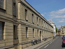


Pusey Street links the wide thoroughfare of St Giles' Street (opposite St John's College) to the east with St John Street to the west in the St John Street area of central Oxford, England. Pusey Street, formerly called Alfred Street, was renamed in honour of Edward Bouverie Pusey in 1926. The renaming also avoided confusion with another Alfred Street to the south.
The street is about 150 yards long and is one-way eastbound for most of its length.
The street is bordered by two educational establishments of Oxford University. On the north side of the street is the Permanent Private Hall of Regent's Park College. This includes a large white building on the corner with St Giles' called Wheeler Robinson House, the ground floor of which is occupied by an Oxfam bookshop. To the south are St Cross College and Pusey House, founded in 1884. Pusey House Chapel is on the corner with St Giles'.
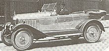
Pusey Lane off Pusey Street was renamed from Alfred Lane at the same time as Pusey Street was renamed. MG Cars of Morris Motors manufactured the MG 14/28 car here from 1924 until the move to larger premises in Bainton Road, North Oxford, in September 1925.
References
- ^ "Streets with changed names". Oxford Streets. Oxford History. Retrieved 9 September 2012.
- Pusey House, St Giles, Oxford Archived 7 September 2008 at the Wayback Machine.
- Pusey Chapel, St Giles, Oxford Archived 7 October 2008 at the Wayback Machine.
- McComb, F. Wilson (2004). MG by McComb (5th ed.). MotorBooks International. p. 46. ISBN 978-0760319895.
External links
51°45′24″N 1°15′39″W / 51.75669°N 1.26078°W / 51.75669; -1.26078
This Oxfordshire location article is a stub. You can help Misplaced Pages by expanding it. |
This England road or road transport-related article is a stub. You can help Misplaced Pages by expanding it. |