| Quatsino Sound | |
|---|---|
| French: Baie Quatsino | |
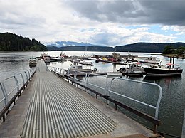
 Coal Harbour, a village located in Holberg Inlet Coal Harbour, a village located in Holberg Inlet | |
 | |
| Location | Vancouver Island, British Columbia |
| Coordinates | 50°30′30″N 127°42′00″W / 50.50833°N 127.70000°W / 50.50833; -127.70000 (Quatsino Sound) |
| Ocean/sea sources | Pacific Ocean |
| Islands | Drake Island |
| Sections/sub-basins | Forward Inlet, Holberg Inlet, Koskimo Bay, Koprino Harbour, Neroutsos Inlet, Rupert Inlet |
| Settlements | Coal Harbour, Holberg, Port Alice, Quatsino, Winter Harbour |
Quatsino Sound is a complex of coastal inlets, bays and islands on northwestern Vancouver Island in the Canadian province of British Columbia. It is the northernmost of the five sounds that pierce the west coast of Vancouver Island, the others being Kyuquot Sound, Nootka Sound, Clayoquot Sound, and Barkley Sound.
Geography
Quatsino Sound extends east from the Pacific Ocean. Near its entrance, on the north side, is Forward Inlet, which branches into several smaller inlets, including the Winter Harbour and village of Winter Harbour. Koskimo Bay and Koprino Harbour are located farther east into Quatsino Sound. Drake Island, which is named after Justice Montague Tyrwhitt-Drake, (Mayor of Victoria 1876-1877) lies near the eastern end of Quatsino Sound, and the long Neroutsos Inlet extends southeast from Drake Island. The town of Port Alice lies near the end of Neroutsos Inlet. East of Drake Island, Quatsino Narrows connects the eastern end of Quatsino Sound to Holberg Inlet and the smaller Rupert Inlet. Quatsino Narrows is a tidal rapids (which are also known in British Columbia as skookumchucks), with currents reaching 9 knots (17 km/h; 10 mph) during flood tide. The sound is located within the Regional District of Mount Waddington.
See also
References
- "Quatsino Sound". Geographical Names Data Base. Natural Resources Canada. Retrieved 2020-06-16.
- "Drake Island". BC Geographical Names.
- "List of Mayors" on "Victoria's Victoria" website
- "Quatsino Narrows". BC Geographical Names.
- Geography from Base Map Online Store Archived 2008-05-09 at the Wayback Machine, TRIM 1:20,000 Digital Base Maps, British Columbia Integrated Land Management Bureau, Base Mapping and Geomatic Services; and Hale, Robert (2007). Waggoner Cruising Guide 2007. Weatherly Press. pp. 267–269. ISBN 978-0-935727-26-5.
External links
![]() Media related to Quatsino Sound at Wikimedia Commons
Media related to Quatsino Sound at Wikimedia Commons
This article about a location on the Coast of British Columbia, Canada is a stub. You can help Misplaced Pages by expanding it. |
This article about a fjord is a stub. You can help Misplaced Pages by expanding it. |