| Quepos | |
|---|---|
| District | |
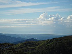
 Quepos coastline as seen from Concepción, in the Tarrazú highlands, Costa Rica Quepos coastline as seen from Concepción, in the Tarrazú highlands, Costa Rica | |
| Quepos district | |
 | |
| Coordinates: 9°27′25″N 84°08′19″W / 9.4570718°N 84.1387451°W / 9.4570718; -84.1387451 | |
| Country | |
| Province | Puntarenas |
| Canton | Quepos |
| Area | |
| • Total | 235.81 km (91.05 sq mi) |
| Elevation | 5 m (16 ft) |
| Population | |
| • Total | 19,858 |
| • Density | 84/km (220/sq mi) |
| Time zone | UTC−06:00 |
| Postal code | 60601 |
Quepos (Spanish pronunciation: [ˈkepos]) is a district of the canton of Quepos, in the province of Puntarenas, Costa Rica.
Toponymy
The town is named for the native Quepo Indians who inhabited the place in the colonial era.
History
The area was home to the native Quepoa people of this specific Costa Rican region. In 1563, Spanish Catholic conquistadores, led by Juan Vázquez de Coronado, settled the area and founded the settlement of San Bernardino de Quepo. The local native Quepo people were then subsequently subjugated by Juan Vázquez and his conquistadores.
In 1746, the Quepo people that remained were transferred to a reservation which already contained another native ethnic group. Quepos offers fishing for numerous varieties of fish, especially Pacific Sailfish. Peak fishing season is from November to April for billfish.
Geography
Quepos has an area of 235.81 km² and an elevation of 5 metres.
The town is about 60 km. south (in a straight line) from Costa Rica's capital, San José, but is 157 km from that city by road if going through the localities of Atenas, Orotina and Tárcoles.
Villages
Administrative center of the district is the town of Quepos.
Other villages are Anita, Bartolo, Boca Naranjo, Cañas, Cañitas, Cerritos, Cerros, Damas, Delicias, Espadilla, Estero Damas, Estero Garita, Llamarón, Llorona, Managua, Manuel Antonio, Marítima, Mona, Papaturro, Paquita, Pastora, Quebrada Azul, Rey, Ríos and Roncador.
Demographics
| Census | Pop. | ±% p.a. |
|---|---|---|
| 1950 | 10,456 | — |
| 1963 | 10,228 | −0.17% |
| 1973 | 8,767 | −1.53% |
| 1984 | 9,093 | +0.33% |
| 2000 | 14,925 | +3.15% |
| 2011 | 19,858 | +2.63% |
| 2022 | 21,531 | +0.74% |
| Source: Instituto Nacional de Estadística y Censos Centro Centroamericano de Población | ||
For the 2011 census, Quepos had a population of 19,858 inhabitants.
Transportation
Road transportation
The district is covered by the following road routes:
Economy

Quepos is the gateway to Manuel Antonio National Park. The city is very tourism-oriented, having many bars and restaurants and a vivacious night-life. Quepos is well known thanks to being the gateway to a popular National Park and beaches in Costa Rica. Several years ago the country's park service imposed limits on the number of visitors to the park (600 per day, and it is closed on Mondays).
Climate
Quepos has a tropical monsoon climate (Am) with moderate to little rainfall from January to March and heavy to very heavy rainfall in the remaining months.
| Climate data for Quepos (1984–2003) | |||||||||||||
|---|---|---|---|---|---|---|---|---|---|---|---|---|---|
| Month | Jan | Feb | Mar | Apr | May | Jun | Jul | Aug | Sep | Oct | Nov | Dec | Year |
| Mean daily maximum °C (°F) | 31.3 (88.3) |
32.0 (89.6) |
32.4 (90.3) |
32.2 (90.0) |
31.4 (88.5) |
30.8 (87.4) |
30.5 (86.9) |
30.4 (86.7) |
30.3 (86.5) |
30.0 (86.0) |
29.8 (85.6) |
30.6 (87.1) |
31.0 (87.7) |
| Mean daily minimum °C (°F) | 22.0 (71.6) |
22.0 (71.6) |
22.6 (72.7) |
23.5 (74.3) |
23.3 (73.9) |
23.1 (73.6) |
22.8 (73.0) |
22.7 (72.9) |
22.6 (72.7) |
22.6 (72.7) |
22.6 (72.7) |
22.3 (72.1) |
22.7 (72.8) |
| Average precipitation mm (inches) | 45.9 (1.81) |
25.8 (1.02) |
40.0 (1.57) |
156.9 (6.18) |
389.0 (15.31) |
413.3 (16.27) |
444.9 (17.52) |
468.7 (18.45) |
544.3 (21.43) |
533.5 (21.00) |
349.0 (13.74) |
159.7 (6.29) |
3,571 (140.59) |
| Average precipitation days | 7.2 | 4.2 | 5.4 | 12.4 | 22.9 | 23.6 | 25.7 | 26.4 | 26.5 | 26.7 | 23.2 | 15.2 | 219.4 |
| Source: World Meteorological Organization | |||||||||||||
References
- ^ "Declara oficial para efectos administrativos, la aprobación de la División Territorial Administrativa de la República N°41548-MGP". Sistema Costarricense de Información Jurídica (in Spanish). 19 March 2019. Retrieved 26 September 2020.
- División Territorial Administrativa de la República de Costa Rica (PDF) (in Spanish). Editorial Digital de la Imprenta Nacional. 8 March 2017. ISBN 978-9977-58-477-5.
- "Área en kilómetros cuadrados, según provincia, cantón y distrito administrativo". Instituto Nacional de Estadística y Censos (in Spanish). Retrieved 26 September 2020.
- "Instituto Nacional de Estadística y Censos" (in Spanish).
- Centro Centroamericano de Población de la Universidad de Costa Rica. "Sistema de Consulta a Bases de Datos Estadísticas" (in Spanish).
- "Censo. 2011. Población total por zona y sexo, según provincia, cantón y distrito". Instituto Nacional de Estadística y Censos (in Spanish). Retrieved 26 September 2020.
- "World Weather Information Service". World Meteorological Organization. Retrieved 18 August 2024.
| Puntarenas | |
|---|---|
| Esparza | |
| Buenos Aires | |
| Montes de Oro | |
| Osa | |
| Quepos | |
| Golfito | |
| Coto Brus | |
| Parrita | |
| Corredores | |
| Garabito | |
| Monteverde | |
| Puerto Jiménez | |
External links
 Quepos travel guide from Wikivoyage
This Costa Rican location article is a stub. You can help Misplaced Pages by expanding it. |