| This article needs additional citations for verification. Please help improve this article by adding citations to reliable sources. Unsourced material may be challenged and removed. Find sources: "Quimbaya, Quindío" – news · newspapers · books · scholar · JSTOR (January 2021) (Learn how and when to remove this message) |
| Quimbaya, Quindío | |
|---|---|
| Municipality and town | |
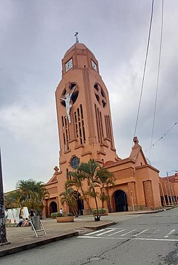
 Jesus, Mary and Joseph Church in the main park Jesus, Mary and Joseph Church in the main park | |
 Flag Flag Coat of arms Coat of arms | |
 Location of the municipality and town of Quimbaya, Quindío in the Quindío Department of Colombia. Location of the municipality and town of Quimbaya, Quindío in the Quindío Department of Colombia. | |
| Country | |
| Department | Quindío Department |
| Elevation | 1,339 m (4,393 ft) |
| Population | |
| • Total | 31,844 |
| Time zone | UTC-5 (Colombia Standard Time) |
Quimbaya is a town and municipality in the western part of the department of Quindío, Colombia. It's 20 km northwest of the departmental capital Armenia. The name of the city derives from the name of the Precolumbian culture that inhabited the area, the Quimbaya civilization. Located along the Colombian coffee growing axis, the municipality was made part of the "Coffee Cultural Landscape" UNESCO World Heritage Site in 2011.
History
Quimbaya was founded in 1914 by Juan de J. Buitrago, and became a municipality in 1922. In 2023 the town had an estimated population of 31,844.
Geography
Quimbaya is bounded to the north and west by the Valle del Cauca Department, with La Vieja River forming the western limit. To the south, the Roble River forms the limit with the municipalities of Montenegro and Circasia. The eastern boundary is with the municipality of Filandia.

Climate
Quimbaya has a subtropical highland climate with an average annual temperature of 21°C.
Tourism

The National Agricultural and livestock Park (Spanish: El Parque Natural De La Cultura Agropecuaria), PANACA, is located 7 km west of the main township. The 47-hectare park contains a variety of interactive exhibits, including more than 200 species of animals. Along with the National Coffee Park in Montenegro, the theme park is one of major tourist attractions of the department.
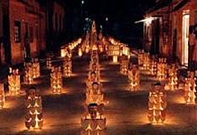
The most important cultural event is the Candles and Lanterns Festival (full name in Spanish: Fiesta Nacional del Concurso de Alumbrados con Velas y Faroles), which began in 1982 and is held each year on 7 and 8 December (Día de las Velitas). Each of the barrios in the township compete to produce the most spectacular lighting arrangements, and many visitors come from throughout Colombia to admire the displays. The festival is held in honor of the Catholic holy day, the Feast of the Immaculate Conception, on 8 December.
References
- "Coffee Cultural Landscape". UNESCO World Heritage List. United Nations Educational, Scientific, and Cultural Organization. Retrieved 25 Apr 2011.
- Telefónicas, Telencuestas-Encuestas. "Cuántos habitantes tiene Quimbaya, Quindío en 2023". Telencuestas (in Spanish). Retrieved 2023-09-27.
- "Quimbaya - Gobernación del Quindio". quindio.gov.co. Retrieved 2023-09-27.
| Municipalities of the Quindío Department, Colombia | ||
|---|---|---|
| Population over 50,000 |  | |
| Population over 20,000 | ||
| Population under 20,000 | ||
4°38′N 75°45′W / 4.633°N 75.750°W / 4.633; -75.750
Category: