| Râca | |
|---|---|
| Commune | |
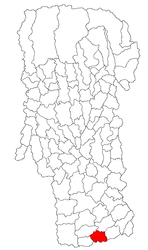
 Location in Argeș County Location in Argeș County | |
 | |
| Coordinates: 44°26′N 25°2′E / 44.433°N 25.033°E / 44.433; 25.033 | |
| Country | Romania |
| County | Argeș |
| Government | |
| • Mayor (2020–2024) | Nicușor-Sorin Popescu (PSD) |
| Area | 42.6 km (16.4 sq mi) |
| Elevation | 165 m (541 ft) |
| Population | 951 |
| • Density | 22/km (58/sq mi) |
| Time zone | EET/EEST (UTC+2/+3) |
| Postal code | 117596 |
| Vehicle reg. | AG |
| Website | www |
Râca is a commune in Argeș County, Muntenia, Romania. It is composed of three villages: Adunați, Bucov, and Râca. These were part of Popești Commune until 2003, when they were split off.
The commune lies in the Wallachian Plain. It is located at the southern extremity of Argeș County, on the border with Teleorman County.
References
- "Populaţia rezidentă după grupa de vârstă, pe județe și municipii, orașe, comune, la 1 decembrie 2021" (XLS). National Institute of Statistics.
This Argeș County location article is a stub. You can help Misplaced Pages by expanding it. |
