| This article needs additional citations for verification. Please help improve this article by adding citations to reliable sources. Unsourced material may be challenged and removed. Find sources: "Ras Doumeira" – news · newspapers · books · scholar · JSTOR (March 2018) (Learn how and when to remove this message) |
| Ras Doumeira | |
|---|---|
| Cape | |
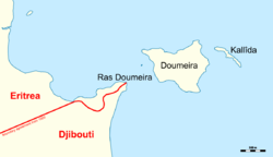
 Map of Ras Doumeira with the de facto border Map of Ras Doumeira with the de facto border | |
| Coordinates: 12°42′40″N 43°8′0″E / 12.71111°N 43.13333°E / 12.71111; 43.13333 | |
| Location | Djibouti |
| Native name | |
Ras Doumeira (Cape Doumeira, Somali: Raas Dumeera) is a geographic cape that extends into the Red Sea, towards the Doumeira Islands. The area is in the north of Djibouti and also border Eritrea, and was the subject of the 2008 border dispute between the two countries. In September 2018 ten years after the conflict, it was announced that Djibouti and Eritrea agreed to normalize their relations.
References
- "US condemns Eritrea 'aggression'". 12 June 2008. Retrieved 15 June 2008.