| This article includes a list of general references, but it lacks sufficient corresponding inline citations. Please help to improve this article by introducing more precise citations. (January 2019) (Learn how and when to remove this message) |
| Redoute des Trois Communes | |
|---|---|
| Saorge, France | |
 | |
| Coordinates | 44°00′04″N 7°25′59″E / 44.00111°N 7.43306°E / 44.00111; 7.43306 (redoute des Trois-Communes) |
| Type | Fort, Séré de Rivières system |
| Site information | |
| Controlled by | |
| Open to the public | No |
| Condition | In ruins |
| Site history | |
| Built | 1897-1899 (1897-1899) |
| Battles/wars | Battle of Authion |
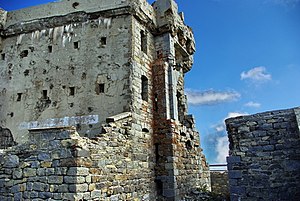
The Redoute des Trois Communes is a French fort, located in the commune of Saorge, Alpes-Maritimes.
Built in 1897 as part of the Séré de Rivières system, it was one of the first French forts to be constructed of reinforced concrete. Situated at an altitude of 2080 metres at the highest summit of the Authion massif, it was intended to defend the Franco-Italian border.
During World War II, the redoubt was held by German troops of the 34th division. It saw combat when the French offensive during the battle of Authion. On April 12, after artillery and aviation strikes, it was approached by 5 volunteers of the 1st Free French Division supported by a tank, who obtained the surrender of the 38-strong garrison.
External links
- Redoute des 3 Communes, chemin de Mémoire, Ministry of the Armed Forces (France)
- La redoute ou blockhaus de la Pointe des Trois Communes et les baraquements de la tête de l'Authion, www.fortiffsere.fr
This Alpes-Maritimes geographical article is a stub. You can help Misplaced Pages by expanding it. |
This article about a French building or structure is a stub. You can help Misplaced Pages by expanding it. |
This military base or fortification article is a stub. You can help Misplaced Pages by expanding it. |