You can help expand this article with text translated from the corresponding article in German. (September 2011) Click for important translation instructions.
|
| Reichenbach | |
|---|---|
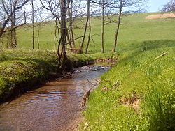
 The Reichenbach near Heimbacher Mühle The Reichenbach near Heimbacher Mühle | |
| Location | |
| Country | Germany |
| State | Bavaria |
| Reference no. | DE: 247726 |
| Physical characteristics | |
| Source | |
| • location | Confluence of Schützbach and Kirchengrundbach in Reichenbach |
| • coordinates | 50°02′38″N 9°08′24″E / 50.043873°N 9.140099°E / 50.043873; 9.140099 |
| Mouth | |
| • location | near Mömbris in the Kahl |
| • coordinates | 50°03′47″N 9°10′44″E / 50.063136°N 9.178798°E / 50.063136; 9.178798 |
| Length | 5.0 km (3.1 mi) (with Schützbach) |
| Basin features | |
| Progression | Kahl→ Main→ Rhine→ North Sea |
The Reichenbach is a left tributary of the Kahl in the northern Spessart in Lower Franconia, Bavaria, Germany. It is 5 km (3.1 mi) long and begins at the confluence of Schützbach and Kirchengrundbach in Reichenbach. Near Mömbris the Reichenbach empties in the Kahl.
Together with Westerbach, Sommerkahl and Geiselbach, the Reichenbach is one of the largest tributaries of the Kahl.
Tributaries
- Schützbach (left headstream)
- Kirchengrundbach (right headstream)
- Steinbach (right)
- Hohlenbach (left)
- Heimbach (left)
See also
References
- Complete table of the Bavarian Waterbody Register by the Bavarian State Office for the Environment (xls, 10.3 MB)
This article related to a river in Bavaria is a stub. You can help Misplaced Pages by expanding it. |