| Reipå | |
|---|---|
| Village | |
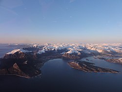
 View of the village View of the village | |
  | |
| Coordinates: 66°54′36″N 13°38′13″E / 66.9099°N 13.6370°E / 66.9099; 13.6370 | |
| Country | Norway |
| Region | Northern Norway |
| County | Nordland |
| District | Salten |
| Municipality | Meløy Municipality |
| Area | |
| • Total | 0.45 km (0.17 sq mi) |
| Elevation | 10 m (30 ft) |
| Population | |
| • Total | 266 |
| • Density | 591/km (1,530/sq mi) |
| Time zone | UTC+01:00 (CET) |
| • Summer (DST) | UTC+02:00 (CEST) |
| Post Code | 8146 Reipå |
Reipå is a village in Meløy Municipality in Nordland county, Norway. It is located along Norwegian County Road 17 about 6 kilometres (3.7 mi) north of the village of Ørnes. The lakes Lysvatnet and Markvatnet both lie to the east of the village. Fore Church is located in Reipå, serving northern Meløy.
The 0.45-square-kilometre (110-acre) village has a population (2023) of 266 and a population density of 591 inhabitants per square kilometre (1,530/sq mi).
References
- ^ Statistisk sentralbyrå (2023-12-23). "Urban settlements. Population and area, by municipality".
- "Reipå, Meløy (Nordland)". yr.no. Retrieved 2019-02-02.
- "Informasjon om stadnamn". Norgeskart (in Norwegian). Kartverket. Retrieved 2024-09-29.
This Nordland location article is a stub. You can help Misplaced Pages by expanding it. |