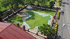
| Relief Map of Mindanao | |
|---|---|
 | |
| Artist | Jose Rizal |
| Completion date | 1892 (1892) |
| Subject | Geography of Mindanao |
| Designation | National Cultural Treasure |
| Location | Dapitan Heritage Zone, Dapitan |
| Coordinates | 8°39′17″N 123°25′29″E / 8.65485°N 123.42475°E / 8.65485; 123.42475 |
| National Cultural Treasures | |
| Official name | Relief Map of Mindanao |
| Designated | May 24, 2011; 13 years ago (2011-05-24) |
| Region | Zamboanga Peninsula |
| Legal basis | Resolution No. 3 |
| Marker date | June 20, 2005; 19 years ago (2005-06-20) |
The Relief Map of Mindanao in Dapitan, Philippines, is a landscaping work by Jose Rizal. It is situated near the St. James the Greater Church.
It is recognized by the National Historical Commission of the Philippines as a National Cultural Treasure
References
- "Maps and Plans Made by Rizal". JoseRizal.ph. Jose Rizal University. Retrieved November 5, 2023.
- "Tourism". City of Dapitan Website. Retrieved November 5, 2023.
- Lapeña, Carmela (June 1, 2011). "Dapitan in Mindanao named historical zone". GMA News. Retrieved November 5, 2023.
This article about a location in the Philippines is a stub. You can help Misplaced Pages by expanding it. |