| The Remarkables | |
|---|---|
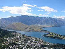
 The Remarkables and Lake Wakatipu from Queenstown. The Remarkables and Lake Wakatipu from Queenstown. | |
| Highest point | |
| Peak | Double Cone |
| Elevation | 2,319 m (7,608 ft) |
| Coordinates | 45°04′19″S 168°48′29″E / 45.072°S 168.808°E / -45.072; 168.808 |
| Dimensions | |
| Length | 40 km (25 mi) |
| Naming | |
| Etymology | Named for being one of two ranges in the world that faces due north and due south, explorers found it to be "Remarkable" . |
| Native name | Kawarau (Māori) |
| Geography | |
 | |
| Country | |
| Region | |
| Range coordinates | 45°09′S 168°50′E / 45.150°S 168.833°E / -45.150; 168.833 |
| Geology | |
| Formed by | Tectonic uplift / glaciation |
| Rock type(s) | Schist, Greywacke |
The Remarkables (Māori: Kawarau) are a mountain range and skifield in Otago in the South Island of New Zealand. Located on the southeastern shore of Lake Wakatipu, the range lives up to its name by rising sharply to create a remarkable backdrop for the waters. The range is clearly visible from the nearby town of Queenstown.
The highest point in the range is Single Cone (2319 metres). The adjacent Tapuae-o-Uenuku / Hector Mountains southeast of the Remarkables culminate in Mount Tūwhakarōria (2307 m).
There are a number of small lakes on the mountains including Lake Alta which forms part of the Remarkables Skifield.
Name
The original Ngāi Tahu inhabitants called the mountains Kawarau, and gave the same name to the Kawarau River which starts beneath them.
The mountains were named The Remarkables by Alexander Garvie in 1857–58, allegedly because they are one of only two mountain ranges in the world which run directly north to south, the other one being in the Rocky Mountains. An alternate explanation for the name given by locals is that early Queenstown settlers, upon seeing the mountain range during sunset one evening, named them the Remarkables to describe the sight.
Skifield
During the winter months, the Remarkables skifield has skiing and other winter activities. The ski area has three mountain bowls covering 220 ha (540 acres) with eight lifts (4 chairlifts, 4 magic carpets). Terrain is rated as 30% beginners, 40% intermediate and 30% advanced. Average annual snowfall is 3.67 metres. In 2007 automated snowmaking was installed and a new snow groomer has also been acquired. There's also a snow tubing park and in 2008 a terrain park was developed. The Remarkables are part of NZSki, which incorporate Coronet Peak and Mt Hutt. In the 2014 winter season, a new lodge base building and a new 6-seater express detachable chairlift have been inaugurated. A second 6-seater express detachable chairlift has been installed in 2020 to replace an old chairlift. In the late future, there is plans to extend the terrain and improve the ski field. An independent operator have released his plans to build a gondola lift from the Remarkables Town Centre to the ski field's base.

| The Remarkables Skifields | |
|---|---|
| Elevation | 1943 metres |
| Vertical | 357 metres |
| Skiable Area | 220 hectares |
| Lifts | 4 chairlifts (2 detachable 6 seater, 2 quad), 4 surface conveyor lifts, Highest lifted point: 1943 metres Lowest lift: 1622 metres |
| Lift Operation | 9.00 am - 4.00 pm |
| Terrain | 30% Beginner, 40% Intermediate, 30% Advanced |
| Standard Season | 10 June – 1 October |
| Average Snowfall | 3.67 metres per year (excluding snowmaking) |
| Snowmaking | Terrain park, beginners' area, Alta Green, Casterway, Gotham City and Turquoise novice trails and Ozone Tubing Park |
| Nearest Town | Queenstown (28 km/45 minutes) |


References
- ^ "Place name detail: The Remarkables". New Zealand Gazetteer. New Zealand Geographic Board. Retrieved 19 April 2022.
- "Central Otago names confirmed". Waatea News. 11 December 2013. Archived from the original on 27 April 2015.
- "Kawarau". Kā Huru Manu. Nga Rūnanga o Ngāi Tahu. Retrieved 19 October 2021.
- Miller. F.W.G. (1949) Golden Days of Lake County. Whitcomb and Toombs. Pg 352.
- qrc (17 October 2019). "Some Queenstown fun facts - did you know..." QRC. Retrieved 3 August 2023.
- NZ Ski facts, Accessed 22 January 2018
- Louisson, Simon (4 April 2007). "Queenstown pushes power of popularity". The New Zealand Herald. Retrieved 21 November 2011.
External links
- The Remarkables official website
- NZSki Ltd official website
- The Remarkables Webcams and Weather Report
- Ski Queenstown official website
| Queenstown-Lakes District, Otago, New Zealand | |
|---|---|
| Seat: Queenstown | |
| Populated places | |
| Geographic features | |
| Facilities and attractions | |
| Government | |
| Organisations | |
| Sports | |
| Ski areas and resorts in New Zealand | |||||||||||||
|---|---|---|---|---|---|---|---|---|---|---|---|---|---|
| Commercial skifields |
| ||||||||||||
| Club skifields |
| ||||||||||||
| 1: Indoor ski slope 2: Former club skifield 3: Heliskiing 4: Cross-country skiing 5: Terrain park 6: Closed | |||||||||||||
| Skifields in Otago, New Zealand | |
|---|---|
| List of New Zealand skifields |
| Places associated with Tolkien tourism | |||||||||||||||||||||||
|---|---|---|---|---|---|---|---|---|---|---|---|---|---|---|---|---|---|---|---|---|---|---|---|
| Film locations (New Zealand) |
| ||||||||||||||||||||||
| Locations associated with Tolkien |
| ||||||||||||||||||||||
| |||||||||||||||||||||||