Township in Ontario, Canada
| Admaston/Bromley | |
|---|---|
| Township (lower-tier) | |
| Township of Admaston/Bromley | |
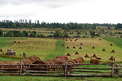
 Typical countryside near Douglas Typical countryside near Douglas | |
  | |
| Coordinates: 45°31′45″N 76°53′49″W / 45.52917°N 76.89694°W / 45.52917; -76.89694 | |
| Country | Canada |
| Province | Ontario |
| County | Renfrew |
| Formed | January 1, 2000 (2000-01-01) |
| Government | |
| • Type | Township |
| • Mayor | Michael Donohue |
| • MP | Cheryl Gallant (CPC) |
| • MPP | John Yakabuski (OPC) |
| Area | |
| • Land | 519.59 km (200.61 sq mi) |
| Population | |
| • Total | 2,995 |
| • Density | 5.8/km (15/sq mi) |
| Time zone | UTC-5 (EST) |
| • Summer (DST) | UTC-4 (EDT) |
| Postal code | K0J |
| Area codes | 613,343 |
| Website | www |
Admaston/Bromley is an incorporated township in Renfrew County, Eastern Ontario, Canada. It was formed on January 1, 2000, when Admaston and Bromley Townships were amalgamated. It takes part of its name from Admaston, Staffordshire, a small English hamlet.
Communities
The township comprises the communities of Admaston, Balsam Hill, Belangers Corners, Bromley, Bulgers Corners, Connaught, Douglas, Ferguslea, Fremo Corners, Kellys Corner, Martins Corner, McDougall, Moores Lake, Mount St. Patrick, Northcote, Oakgrove, Osceola, Payne, Pine Valley, Renfrew Junction, Rosebank, Shamrock, and Wolftown.
Admaston
The community, as well as the township, were named for the little village of Admaston, Staffordshire, the native home of Sir Charles Bagot, second Governor General of the Province of Canada .
Bromley
The community, as well as the township, took its name from Bagot's Bromley in Staffordshire, England, home of the Bagot family.
Douglas
When the post office was established in 1854, Scottish settlers chose the name Douglas after a town in Lanarkshire, Scotland. The town of Douglas is the third of five chutes along the Bonnechere River. The others being Castleford, Renfrew, Fourth Chute and Eganville. The chutes were used for moving timber past rapids and waterfalls; Douglas had a 21-foot (3.4 m) waterfall over which log drivers had to shepherd their timber.
Mount St. Patrick
The community was most likely first settled in the 1830's by squatters on the land, as there was no land registry until the 1850's. The settlers, almost solely Irish Catholics, named the village after Croagh Patrick, in County Mayo, Ireland.
Demographics
In the 2021 Census of Population conducted by Statistics Canada, Admaston/Bromley had a population of 2,995 living in 1,136 of its 1,305 total private dwellings, a change of 2% from its 2016 population of 2,935. With a land area of 519.59 km (200.61 sq mi), it had a population density of 5.8/km (14.9/sq mi) in 2021.
| Year | Pop. | ±% |
|---|---|---|
| 2001 | 2,824 | — |
| 2006 | 2,716 | −3.8% |
| 2011 | 2,844 | +4.7% |
| 2016 | 2,935 | +3.2% |
| 2021 | 2,995 | +2.0% |
| Source: Statistics Canada, 2016 2011, 2006, earlier | ||
|
| ||||||||||||||||||||||||||||||||||||||||||||||||||||||||||||||||||||||||||||||||||||||||||||||||||
Local government
List of former mayors:
- Raye-Anne Briscoe (2000–2014)
- Michael Donohue (2014–present)
See also
References
- ^ "Admaston/Bromley". Geographical Names Data Base. Natural Resources Canada. Retrieved 2012-10-06.
- ^ "Admaston/Bromley (Code 3547043) Census Profile". 2021 census. Government of Canada - Statistics Canada. Retrieved 2024-07-17.
- "Origin of Place Names in District: Admaston". The Ottawa Evening Citizen. No. 115. Ottawa, Canada. 30 October 1937. p. 19. Retrieved 16 August 2015.
Admaston in Renfrew county was named after a village in Staffordshire, England.
- "Census Profile, 2016 Census Admaston/Bromley, Township". Statistics Canada. 8 February 2017. Retrieved June 3, 2019.
- "2011 Community Profiles". 2011 Canadian census. Statistics Canada. March 21, 2019.
- "2006 Community Profiles". 2006 Canadian census. Statistics Canada. August 20, 2019.
- "2001 Community Profiles". 2001 Canadian census. Statistics Canada. July 18, 2021.
- ^ "1971 Census of Canada - Population Census Subdivisions (Historical)". Catalogue 92-702 Vol I, part 1 (Bulletin 1.1-2). Statistics Canada: 76, 139. July 1973.
External links
![]() Media related to Admaston/Bromley at Wikimedia Commons
Media related to Admaston/Bromley at Wikimedia Commons
| Places adjacent to Admaston/Bromley | ||||||||||||||||
|---|---|---|---|---|---|---|---|---|---|---|---|---|---|---|---|---|
| ||||||||||||||||
| Renfrew County, Ontario | ||
|---|---|---|
| Cities |  | |
| Towns | ||
| Townships | ||
| First Nations | ||
| Indian reserves | ||
| ||

