| Cape Roca | |
|---|---|
 The Cabo da Roca lighthouse, overlooking the promontory towards the Atlantic Ocean The Cabo da Roca lighthouse, overlooking the promontory towards the Atlantic Ocean | |
| Highest point | |
| Peak | Cabo da Roca, Sintra-Cascais Natural Park |
| Elevation | 140 m (460 ft) |
| Coordinates | 38°46′51″N 9°30′2″W / 38.78083°N 9.50056°W / 38.78083; -9.50056 |
| Naming | |
| Etymology | Roca: Portuguese for sea cliff |
| Native name | Cabo da Roca (Portuguese) |
| Geography | |
 | |
| Country | Portugal |
| Region | Lisboa |
| District | Lisbon |
| Municipality | Sintra |
| Parent range | Serra da Sintra |
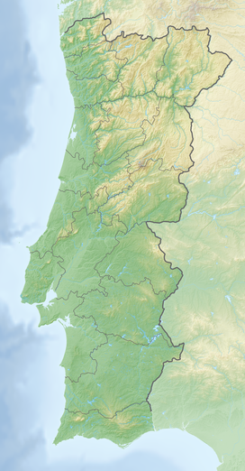
Cabo da Roca (Portuguese: [ˈkaβu ðɐ ˈʁɔkɐ]) or Cape Roca is a cape which forms the westernmost point of the Sintra Mountain Range, of mainland Portugal, of continental Europe, and of the Eurasian landmass. It is situated in the municipality of Sintra, near Azóia, in the south west of the Lisbon District. Notably, the point includes a lighthouse that started operation in 1772.
History
Cabo da Roca was known to the Romans as Promontorium Magnum and during the Age of Sail as the Rock of Lisbon.
Lighthouse
This section is an excerpt from Cabo da Roca Lighthouse. The Cabo da Roca Lighthouse (Portuguese: Farol do Cabo da Roca) is a beacon/lighthouse located 165 metres (541 ft) above the Atlantic Ocean, on Portugal's (and continental Europe's) most westerly extent. It is located in the civil parish of Colares, in the municipality of Sintra, situated on a promontory made up of granite boulders and interspersed limestone. It is a third-order lighthouse, which originally began operating in 1772. It was the first new purpose-built lighthouse to be constructed in the country; the older lighthouses in existence at that time were constructed on existing platforms or from pre-existing beacons.Geography


The cape is within the Sintra-Cascais Natural Park, 42 kilometres west of the city of Lisbon and in the southwest of Sintra. A location (38°47′N 9°30′W / 38.783°N 9.500°W / 38.783; -9.500) is inscribed on a stone plaque, located on a monument at the site.
The western coast is a mixture of sandy beaches and rocky cliff promontories: around Cabo da Roca, cliffs are more than 100 metres in height, and cut into crystalline rocks, composed of strongly folded and faulted sedimentary units. These forms are disturbed by dikes and small beaches. This promontory of "high" beaches is the extreme western immersion of the ancient eruptive Sintra massif, as evident from the rose-coloured granite in the north and syenite of the Ribeira do Louriçal in the south. In the vicinity of the Cape, there are geomorphological examples of gabbro-diorite, volcanic breccia, and granite.
Part of the granite formations show evidence of strong coastal erosion, while in other areas there are limestone deposits embedded in the granite.
Much of the vegetation on this cape is low-lying and adapted to saltwater and windy conditions. Once home to a variety of plant life, Cabo da Roca has been overrun with the invasive plant species Carpobrotus edulis. This creeping, mat-forming plant, a member of the Aizoaceae succulent family, was introduced as ground cover by local residents several decades ago, but now covers much of the arable land on Cabo da Roca.
Many migratory and marine birds roost temporarily along the cliffs and protected coves of the coastal area.
Climate
The climate present at Cape Roca is extremely moderated by the ocean. Due to seasonal upwelling, the area comprising the cape has cool, stable summers with little to no rainfall but very common occurrences of fog which boosts the humidity and decreases insolation. Summer is also the windiest season of the year with July and August averaging around 15 km/h (9.3 mph). On the other hand, winters are rainy and have mild temperatures especially during the night, though the amount of precipitation received in this season is unparalleled with other places nearby such as the Sintra Mountains which can receive triple that precipitation. Due to the seasonal lag, September is the warmest month.
| Climate data for Cabo da Roca (Lighthouse), 1961–1990 normals, 1940–1966 sun hours, altitude: 142 m (466 ft) | |||||||||||||
|---|---|---|---|---|---|---|---|---|---|---|---|---|---|
| Month | Jan | Feb | Mar | Apr | May | Jun | Jul | Aug | Sep | Oct | Nov | Dec | Year |
| Mean daily maximum °C (°F) | 14.0 (57.2) |
13.8 (56.8) |
15.5 (59.9) |
15.9 (60.6) |
17.0 (62.6) |
19.2 (66.6) |
20.2 (68.4) |
20.7 (69.3) |
21.1 (70.0) |
19.4 (66.9) |
16.6 (61.9) |
14.6 (58.3) |
17.3 (63.2) |
| Daily mean °C (°F) | 11.6 (52.9) |
11.6 (52.9) |
12.5 (54.5) |
13.3 (55.9) |
14.5 (58.1) |
16.5 (61.7) |
17.6 (63.7) |
17.9 (64.2) |
18.1 (64.6) |
16.7 (62.1) |
14.1 (57.4) |
12.1 (53.8) |
14.7 (58.5) |
| Mean daily minimum °C (°F) | 9.3 (48.7) |
9.3 (48.7) |
10.0 (50.0) |
10.7 (51.3) |
11.5 (52.7) |
13.8 (56.8) |
15.0 (59.0) |
15.1 (59.2) |
15.1 (59.2) |
14.0 (57.2) |
11.6 (52.9) |
9.6 (49.3) |
12.1 (53.7) |
| Average precipitation mm (inches) | 63 (2.5) |
67 (2.6) |
52 (2.0) |
41 (1.6) |
32 (1.3) |
15 (0.6) |
2 (0.1) |
5 (0.2) |
23 (0.9) |
61 (2.4) |
92 (3.6) |
60 (2.4) |
513 (20.2) |
| Average relative humidity (%) | 78 | 81 | 80 | 79 | 82 | 85 | 86 | 86 | 85 | 80 | 78 | 80 | 82 |
| Mean monthly sunshine hours | 136.4 | 146.9 | 167.4 | 216.0 | 248.0 | 246.0 | 272.8 | 275.9 | 219.0 | 204.6 | 147.0 | 139.5 | 2,419.5 |
| Percent possible sunshine | 45 | 48 | 45 | 55 | 56 | 55 | 60 | 65 | 59 | 59 | 49 | 47 | 54 |
| Source: IPMA | |||||||||||||
| Jan | Feb | Mar | Apr | May | Jun | Jul | Aug | Sep | Oct | Nov | Dec | Year | |
|---|---|---|---|---|---|---|---|---|---|---|---|---|---|
| Cabo da Roca | 13.5 | 14.1 | 13.6 | 13.0 | 13.0 | 13.7 | 15.0 | 15.2 | 13.6 | 13.6 | 13.7 | 13.8 | 13.8 |
See also
Notes
- Fonseca, António Oliveira (November 2010), Relatório da Visita ao Parque Natural Sintra-Cascais (PDF) (in Portuguese), Lisbon, Portugal: Universidade Aberta, retrieved 28 September 2011
- Scheffers, Anja; Kelletat, Dieter (2005), "Tsunami Relics on the Coastal Landscape West of Lisbon, Portugal", Science of Tsunami Hazards (PDF), vol. 23, Essen, Germany: University of Duisburg-Essen, pp. 3–16, retrieved 28 September 2011
References
- ^ "Cape Roca". Encyclopædia Britannica. 2008. Retrieved 20 August 2024.
- "NGA List of Lights". Maritime Safety Information. Springfield, Virginia: U.S. National Geospatial-Intelligence Agency (NGA). 2011. Retrieved 18 July 2011.
- Costa, Patricia (2004). SIPA (ed.). "Farol do Cabo da Roca" (in Portuguese). Lisbon, Portugal: SIPA – Sistema de Informação para o Património Arquitectónico.
- Anja Scheffers and Dieter Kelletat (2005), p. 6
- António Oliveira Fonseca (2010), p. 11
- "IPMA - Monitorização diária". www.ipma.pt. Retrieved 5 June 2021.
- ^ Domingos, Sónia Isabel Sequeira (2008). "Microclimatologia do Município de Sintra com base em estações meteorológicas". Retrieved 5 June 2021.
External links
| Cultural landscape of Sintra | ||
|---|---|---|
| Palaces |  | |
| Religious | ||
| Civic | ||
| Nature | ||
| Miscellaneous | ||