| Rocotopunta | |
|---|---|
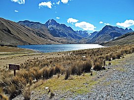
 Lake Querococha and Rocotopunta (on the right) Lake Querococha and Rocotopunta (on the right) | |
| Highest point | |
| Elevation | 4,400 m (14,400 ft) |
| Coordinates | 9°42′20″S 77°18′27″W / 9.70556°S 77.30750°W / -9.70556; -77.30750 |
| Geography | |
 | |
| Location | Peru, Ancash Region |
| Parent range | Andes, Cordillera Blanca |
Rocotopunta (Quechua rukutu, a plant (Capsicum pubescens) and Spanish punta, a peak or ridge) is a mountain in the Cordillera Blanca in the Andes of Peru, about 4,400 m (14,436 ft) high. It is located in the Ancash Region, Recuay Province, Ticapampa District, northeast of Lake Querococha. Rocotopunta lies between Yanamarey Creek to the north and Conde Creek to the south.
References
- ^ escale.minedu.gob.pe - UGEL map of Recuay Province (Ancash Region)
- ^ Peru 1:100 000, Recuay (20-i). IGN (Instituto Geográfico Nacional - Perú).
- Teofilo Laime Ajacopa (2007). Diccionario Bilingüe: Iskay simipi yuyayk’anch: Quechua – Castellano / Castellano – Quechua (PDF). La Paz, Bolivia: futatraw.ourproject.org.
- "Diccionario: Quechua - Español - Quechua, Simi Taqe: Qheswa - Español - Qheswa" (PDF). Diccionario Quechua - Español - Quechua. Gobierno Regional del Cusco, Perú: Academía Mayor de la Lengua Quechua. 2005. (five-vowel-system)
- David Weber, A Grammar of Huallaga (Huánuco) Quechua, University of California Press, p. 185
- Robert Beér, Armando Muyolemaj, Dr. Hernán S. Aguilarpaj, Vocabulario comparativo, quechua ecuatoriano - quechua
This Ancash Region geography article is a stub. You can help Misplaced Pages by expanding it. |